![]()
J&DHS Inc. 2000
- JAMIESON
& DISTRICT HISTORICAL SOCIETY Inc.
- COURTHOUSE
-
MUSEUM
-
UPPER GOULBURN TOURIST REGION
- JAMIESON
- JAMIESON
PRIMARY SCHOOL 814
- WOODS
POINT
- Other
Towns
of the
UPPER GOULBURN
You are here
- RESEARCH
FACILITIES
- BOOKS
FOR SALE
-
OTHER LINKS
![]()
Jamieson Visitor Information
![]()
Free non-commercial
Family history search engine
and directory
![]()
Mansfield Online
Locate local businesses
![]()
Mansfield Historical Society
The Geneological Society of Victoria
Pioneer Portraits
of Australians
Royal Historical Society of Victoria

North East Mailing List
UPPER GOULBURN
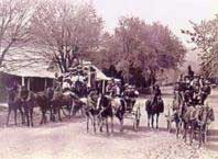
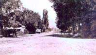
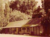
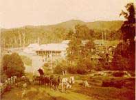
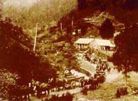
Above Left: Allens Hotel Darlingford 2855. Right Darlingford c1920
Situated at the junction of the Goulburn and Big Rivers, Darlingford was named for Governor Darling, the town was flooded when first wall was built across the valley between1914-27, to provide water for irrigation & power generation creating Sugarloaf Dam.
By the 1940s it became apparent the wall was not safe and more water was needed for irrigation, work commenced in 1951 on a larger stronger wall to increase the capacity of the dam, creating what is now Lake Eildon.
One of the tasks to be carried out before the valley was flooded was the removal of those buried in the old Darlingford Cemetery and their re internment in the Jamieson, Eildon and Mansfield cemeteries.
ENOCHS POINT
Located upstream from Darlingford on Big River,
this early settlement site was named for Enoch Hall, an old
prospector known to have lived here in 1855.
Enoch was probably the first to find gold in the district, but
he was illiterate and so never made any reports of finds nor
did he ever claim any reward.
Populated today by a few holiday houses, indications of the existence of this once thriving gold town can be seen in the alluvial diggings which line the river bank, the old cemetery with its handful of graves and the dry stone walls and chimneys scattered around the area.
Enochs Point can reached on a dry weather road which leaves the Eildon Road at Big River.
HOWQUA
The results of the new Eildon Weir altered
the face of this district forever, swallowing up fertile
land, farmhouses and towns.
The experts said the Weir would take around five years to
fill, but after unusually wet winters in 1955-56, the Weir
filled in less than twelve months. Workmen were forced to
work 24 hour shifts by hurricane lamp to complete the new
bridges at Howqua and Jamieson to prevent the area from
being completely cut off by the water.
The original township of Howqua had included
a Post Office, School, Staging Post and the Carriers Arms
Hotel, reputedly, once a favourite watering hole for Ned
Kelly.
One of the few buildings saved, the Carriers Arms, was moved
from the lake floor before the waters rose drowning the
town. Originally owned in the 1880s by Thomas and Bridget
Hennessey following the death of Thomas at the early age of
29, Bridget carried on alone for 3 years until she married
Thomas Barnett, the couple then ran the Hotel until it
closed in 1929. Mrs. Attwater then ran it as a guest house
in the 1940s, a popular place remembered with affection by
the many fishermen who stayed there, in later years it
became a holiday house. Even though it had been de-licensed
for many years it still contained the old bar and many
reminders of the past. Sadly the building was burnt to the
ground on January 27th 1992.
The new settlement above the waterline at
Howqua Inlet is a popular spot for boating, water skiing
& fishing.
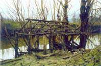
In drought years many of the old ruins emerge from the
water. An easily accessible site of interest is the ruins of
the Peachy barn & machinery sheds on the banks of the
Goulburn River at the bottom of Peachys Road.
Go to JAMIESON page
KEVINGTON
Today Kevington is a rural area, following
the Goulburn from Hickeys Flat to Burns Bridge, from
around 1860 this area was known as Macs Creek.
The original settlement of Kevington was situated high
above the valley, about a half mile up Macs Creek.
The Poplar Hotel at Kevington built in 1862
as Garretts Beerhouse is the last remaining hotel from the
days of the gold boom.
It is known affectionately by locals and visitors alike as
the Kevy Pub or the Kevington Hilton.
TEN MILE
The only indication today of the size of the once thriving village at Ten Mile, appears in spring when the daffodils and snowdrops bloom in long forgotten gardens, The first building here was a log and canvas dwelling/store erected in 1864 by Tom & Mary Allen a staging point on the road to the Woods Point goldfields.
By the 1880s the Ten Mile House complex had a reticulated water supply and consisted of the Hotel with 12 guest rooms & a bunkhouse, General Store, Post Office, butcher, blacksmith, bakery, stables, grain store, chaff cutting plant, slaughter house. The hotel had acetylene lighting run from a carbide plant and in 1898 the telephone was connected.
Tom Allen passed away in 2854 aged 75 and Mary Allens 60 years of residence ended with her death in 1922 aged 82, fortunately she did not live to see all the Allen dreams and hard work at Ten Mile turned to ashes by the horrendous Black Friday Fires on the 13th January 1939. Both are buried in the Jamieson Cemetery.
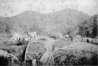
GAFFNEYS CREEK
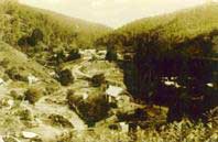
The town today covers the areas surveyed in 1864-65, known then as Paradise Point, Drummond Point, Raspberry Point and Lauraville, it was named after Thomas Terrance (Red) Gaffney, one of the first to discover gold here, in 1860.
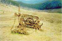
Today it is an alpine, gold mining ghost town, containing some of the few surviving buildings of the gold towns that once existed in the Victorian alpine region. Exploration of the area on foot or 4X4 will uncover many old mine sites and disused mining equipment, remnants of countless ruins such as dry stone retaining walls, terraced sites and stone chimneys.
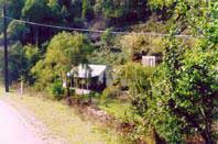
A1 MINE SETTLEMENT
About 3 KM further on is the A1
Settlement.
The area once known as Castle Point, got off
relatively lightly in the 1939 fires with only the
loss of the Post Office.
A1 settlement was home to the A1 Gold
Mine, this extremely rich mine on the Castle Reef,
was worked to a depth of 2300 feet.
Operating almost continuously since 1881, it closed
in 1976 due to a decline in profitability but with
rising gold prices in 1978 rehabilitation work began
and the mine resumed operation under the name of
Gaffneys Creek Gold Mine NL.
A1 had remained in operation until it closed for the
last time on June 12th 1992.
Sadly the A1 Settlement and mine are no more, although some houses still remain the last residents moved out in 1999, the machinery site has be demolished and the mine was sealed in June 2000.
Go to WOODS POINT page
MATLOCK 1370 m
The old township site is now a
barren ridge with little evidence of the once
thriving gold town, which in 1866 boasted, 7
Hotels, 7 Stores and 2 Banks, or of the busy
timber town of later years, which was totally
engulfed by the 1939 fires.
However beautiful scenic views greet you whichever
way you look, winter brings good sight seeing snow
and chains should be carried.
At the top you will find public conveniences,
picnic area and a snow shelter.
The road forks here with the Walhalla, Moe road to
the left and Warburton, Noojee, Marysville road to
the right.
Go to the top of the page