| Title |
Description |
Location |
Melway |
Inscription |
Notes |
Image |
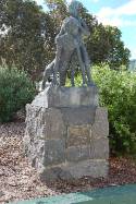
The Original
Children – 1980 |
A statue and
bluestone pedestal with two plaques. Both plaques are
bronze with raised bronze lettering. |
At the
north-west corner of the Ashwood College grounds, close
to the corner of Vannam Drive and Poplar Avenue, entry
from the car park nearest the corner, or the car park to
the south of the Drama complex. The statue is
between the new Drama complex and the old school canteen. |
60H10
|
“THE
ORIGINAL CHILDREN”
SCULPTURE BY
STANLEY HAMMOND, M.B.E.
DONATED TO
ASHWOOD HIGH SCHOOL BY M. MCKAY, B.A.
PRINCIPAL
1968-1976
Plaque 2: (East
face)
THIS SCULPTURE
WAS UNVEILED BY THE HON. A.J. HUNT, M.L.C.
MINISTER OF
EDUCATION ON 29 JULY 1980
|
Note,
23/2/08:
Access may be gained to the school grounds on weekends
but during school hours, an approach would need to be
made to the school office with a request to view.Donated by former principal, Mr. McKay and
erected in the school grounds. |
 |
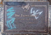
| Zonta Rose |
Australia
1788-1988 “THE ZONTA ROSE”
Bicentenary Gift of the
Zonta Club of Waverley 1988
|
A bronze
plaque and round concrete plinth. The plaque has raised
bronze lettering located in the south edge of the grassed reserve at the
SE corner of Hight Street Rd and Stephensons Rd.
|
61E11
|
Australia 1788-1988
“THE ZONTA
ROSE”
Bicentenary Gift
of the Zonta Club of Waverley1988
|
AUSTRALIA’S BI-CENTENNARY, 1788-1988.
Note,
21/3/2008:
A gift from the Zonta Club for the nation’s Bicentenary
in 1988.
Some minor graffiti
has appeared on the plaque and shows on the photograph.
Note, 15/4/2008:
Zonta International is a worldwide service organisation
of executives in business and the professions working to
advance the status of women. There are over 33,000
members in more than 1,250 clubs in 67 countries.
|
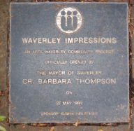
 |
Waverley
Impressions”, Monash Gallery of Art – 1990. |
A plaque with
raised bronze lettering set on a honeycomb rock. |
Monash
Gallery of Art grounds, corner of Ferntree Gully Rd and
Jells Rd, entrance from Jells Rd or via the
Wheelers Hill Library car park, Ferntree Gully Rd. |
71J11
|
WAVERLEY IMPRESSIONS
AN ARTS WAVERLEY
PROJECT
OFFICIALLY
OPENED BY
THE MAYOR
WAVERLEY
CR. BARBARA THOMPSON
ON
29 MAY, 1990
SPONSOR NUBRIK INDUSTRIES
|
Note,
16/3/2008:
The plaque was placed to commemorate the project
undertaken in 1990 to have school children inscribe
individual bricks prior to firing in a kiln. The pavers
were then laid in a circular pattern. |
 |
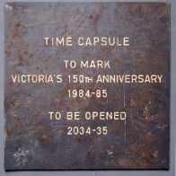
(Old) Glen
Waverley Primary School – Time Capsule – 1985. |
A square
bronze plaque with white lettering. |
Now held at
Waverley Historical Society clubrooms. Originally placed
on a rock in the grounds of Glen Waverley Primary School
– cnr: Waverley and Springvale Road, Glen Waverley. |
70E1
|
TIME CAPSULE
TO MARK
VICTORIA’S 150TH
ANNIVERSARY
1984-85
TO BE OPENED
2034-35
|
Placed
originally in the school grounds above a time capsule.
Note, 22/10/2008:
When the school
closed, the plaque was removed from the grounds and now
is with Waverley Historical Society.
|
|
|
|
|
|
|
|
 |
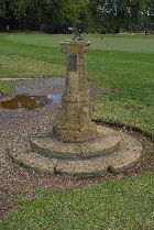
A.E. Millard,
Member of Riversdale Golf Club – 1928. |
A memorial
sandstone sundial and pedestal with a bronze plaque
attached. The plaque has raised bronze lettering. |
The plaque is
adjacent to the main clubhouse, on the west side of the
practice putting green.Located
just off pathway heading towards the first tee on the
east side under tree. |
61A11
|
ERECTED
IN COMMEMORATION
OF OUR LATE
ESTEEMED MEMBER
A E MILLARD
1928
|
Note,
20/2/2008:
Permission to view should be gained from Riversdale Golf
Club.
Erected
in 1928 for A.E. Millard who was an early member of
Riversdale Golf Club
|
 |
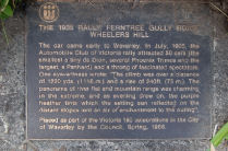
Automobile
Club of Victoria Car Rally, Wheelers Hill (1905) – 1985 |
A bronze
plaque with raised, bronze lettering set into the
concrete footpath. |
Ferntree
Gully Rd, north side, east of Jells Rd, Wheelers
Hill.
Note:
10/2/2008.
The plaque is located on the footpath where the service
road commences, in front of number 893 Ferntree Gully Rd.
|
71J9
|
THE 1905 RALLY, FERNTREE GULLY ROAD WHEELERS
HILL
The car came
early to Waverley. In July, 1905, theAutomobile Club of
Victoria attracted 50 cars (the smallest a tiny de Dion,
several Phoenix Trimos and the largest, a Panhard) and a
throng of fascinated spectators. One eye-witness wrote:
“The climb was over a distance of 1220 yards, (1116
m.) and a rise of 240ft. (73 m.). The panorama of river
flat and mountain range was charming in the extreme, and
as evening drew on, the purple heather tints which the
setting sun reflected on the distant slopes lent an air
of enchantment to the outing.”
Placed as
part of the Victoria 150 celebrations in the City of
Waverley by the Council, Spring, 1985.
|
VICTORIA 150 CELEBRATIONS.
Historical Note,
10/12/2008:
From 1905 to 1940, the steep climb up Ferntree Gully Rd
from the Dandenong Creek to the Wheelers Hill Hotel
formed the hillclimb course for both motor cars and
motorcycles. Another reported course stretched
north along Jells Rd from the Wheelers Hill Hotel and
through surrounding paddocks near Joseph Jell’s property
which is today’s Jells Park.
At least 50 cars and
motorcycles took part in the rally on the testing slope
of Wheelers Hill. The steepness of this hill can be
seen today although it has been cut down and widened.
|
 |
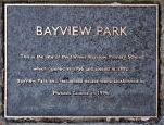
Bayview Park
– Site of Bayview Primary School – 1996 |
A bronze
plaque with raised bronze lettering mounted on a
honeycomb rock. |
McLochlan St,
north side, between Hillview and Howard Avenues.
Located at the eastern entrance to the park, near the
block of shops and almost opposite Donald St. |
70B2
|
BAYVIEW PARK
This is the site
of the former Bayview Primary School
which opened in
1956 and closed in 1992.
Bayview Park and
residential estate were established by
Monash Council
in 1996.
|
Note,
9/6/2008:
Placed to commemorate the opening of the park which is on
the site of the Bayview Primary School.
At the end of 1992
Bayview Primary School closed. Both Mt. Waverley P.S. and
Bayview P.S. existed in the same ‘block’ and whilst
during the peak days of the late 1960s their combined
enrolments exceeded 2000 children, they were now down to
little more than 300 for both. With approximately
sixty children from Bayview joining the Mount Waverley
community for the commencement of the 1993 school year,
the enrolment rose to just over 300.
|
 |
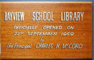
Bayview
Primary School, Opening of Library – 1969 |
A timber
(Victorian Ash) and gold painted plaque |
Now held by
the Waverley Historical Society and located in the rooms
Miller Cres, Mt Waverley |
61E1
|
BAYVIEW SCHOOL LIBRARY
OFFICIALLY
OPENED ON
26TH SEPTEMBER,
1969
by
The Principal, CHARLES H. McCORD
|
Note,
9/4/2008:
Placed originally to commemorate the official opening of
the school’s library in 1969.
The plaque was removed from its original
position when the school and the library were demolished
and placed in the care of Waverley Historical Society.
Note, 9/6/2008:
At the end of 1992 Bayview Primary School closed. Both
Mt. Waverley P.S and Bayview P.S. existed in the same
‘block’ and whilst during the peak days of the late 1960s
their combined enrolments exceeded 2000 children, they
were now down to little more than 300. With sixty
odd children from Bayview joining the Mount Waverley
community for the commencement of the 1993 school year
the enrolment rose to just over 300.
|
 |
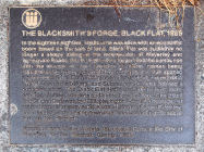
Blacksmith’s
Forge, Black Flat, (Glen Waverley) (1885) – 1985 |
A bronze
plaque with raised bronze lettering set into the concrete
footpath. |
Springvale
Rd, east side, south of Waverley Rd, Glen Waverley. |
71C5
|
THE BLACKSMITH’S FORGE, BLACK FLAT, 1885.
In the
eighteen-eighties, Melbourne was alive with an economic
boom based on the sale of land. Black Flat was suddenly
no longer a sleepy siding at the intersection of Waverley
and Springvale Roads. David Scammell’s forge filled the
surrounds with the sounds of metal banging on metal,
horses being regularly shoed, drays and carts being
restored. J. Duff opened a post office.
Mrs. Ellen
Willey opened a general store. Edward Whitely opened a
bakery and Summers and Wicke opened a butcher’s shop. The
Black Flat Hall was built to host balls, dancing classes,
concerts and chess championships. The Black Flat Cricket
Club was, by 1889, playing one-day matches against teams
as far away as St. Kilda. Historian, Susan Priestley
comments that this rising township “was becoming the
social hub of the district.”
Placed as part
of the Victoria 150 celebrations by the City of Waverley
by the Council, Spring, 1985.
|
VICTORIA 150 CELEBRATIONS
Historical note,
10/2/2008:
An original shop in
the township of Black Flat which grew up around the
corner of Springvale and Waverley Roads. David Scammel
worked the blacksmith’s forge until about 1896.
|
 |
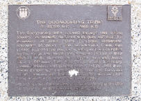
Boonorung
People (C. 40,000 BC) Glen Waverley 1985. |
A bronze
plaque with raised bronze lettering set into the concrete
footpath. |
Waverley Rd,
north side, 90 metres west of Bogong Ave. Now in front of
Holmesglen Institute of TAFE., Waverley Campus. |
71A4
|
THE BOONOORUNG TRIBE
C 40,000 B.C. –
1860 A.D.
The Boonoorung
tribe roamed through this rolling country
“moderately timbered with gum and box” for
thousands of years before European settlement. Alexander
McMillan of the Scotchman’s Creek Run (1840) learned
their language, enjoyed their campfire myths, songs and
music and remained in awe of their physical skills,
strength and stamina. Reverend James Clow of Tirhatuan
Run (1843) wrote of this fun-loving, peaceful, friendly
and trusting people. Yet, by 1860, these proud people had
largely been victims to European enmity, disease and
drink: the thirty-five survivors had been moved to a
reserve in Mordialloc.
Placed as part
of the Victoria 150 celebrations in the City of Waverley,
by the Council, Spring, 1985.
|
VICTORIA 150 CELEBRATIONS
Historical Note:
10/2/2008.
It is a tribute to the nomadic aborigines, who were the
original inhabitants. Acknowledges some of the original
inhabitants of the current City of Monash – the
Boonoorong (Bunurung) peoples.
This plaque may now
be considered inaccurate in the light of recent studies
which have shown that the Woiwurrong and not the
Boonoorong (or Bunurong) were probably the tribal owners
of most of what is considered the current City of Monash.
Note: 14/2/2008
Previous pamphlets give the directions as west of
Montague Street, however this street has now been closed
off at Waverley Road.
|
 |
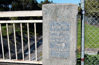
Bridge over
Gardiners Creek Ashwood 1926 |
Two original
granite plaques with recessed, gold lettering, (now
faded) and mounted into concrete bridge piers. |
Two plaques
located on the two concrete bridge pillars, Gardiners
Creek crossing, High Street Rd, Ashwood – south side. |
60H10
|
INSCRIPTION 1:
SHIRE OF
MULGRAVE
THIS BRIDGE WAS
BUILT IN THE YEAR
1926
JOSHUA JORDAN
PRESIDENT
INSCRIPTION 2:
SHIRE OF
MULGRAVE
THIS BRIDGE WAS
BUILT IN THE YEAR
1926
CH COLEMAN JP
ACTING PRESIDENT
|
Historical
note, 28/2/2008:
When the 1926 bridge was replaced in more recent
years, the two original marble foundation stones were
placed into the two concrete rail supports on the
southern side of the new bridge.
The two plaques were
laid by Joshua Jordan and C.H. Coleman for the first
permanent bridge over Gardiners Creek in 1926. The area
would have been known then as Burwood.
|
 |
Bridge over
Gardiners Creek Burwood – 1965 |
A bronze
plaque with raised lettering. |
Plaque is
located on the north side of the bridge on the western
concrete pillar. East of Lytton Street, Burwood. |
60K7
|
THIS BRIDGE WAS CONSTRUCTED
BY THE
COUNTRY ROADS BOARD
IN 1965
TO REPLACE THE
ORIGINAL
BRIDGE OPENED BY
THE HON. W.H. EDGAR
22 AUGUST 1913
|
Note:
9/3/2008.
The plaque is attached to the bridge built in 1965 over
Gardiners Creek, Burwood replacing an earlier bridge
built in 1913.
This
plaque is part of the City of Whitehorse, however because
the bridge is part of the boundary between the two
municipalities, it has been included.
|
 |
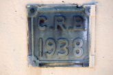
Bridge on
Gardiners Creek, Holmesglen – 1938. |
A small brass
plaque with large, raised lettering. |
The plaque is
attached to the concrete ends of the bridge – east side,
(City of Monash) north corner, facing the carriageway. |
60G12
|
C.R.B.
1938
|
Note
1/3/2008:
Part of the small plaque has been painted over, (very
badly!)
Placed
to mark the construction of the concrete bridge over
Gardiners Creek on the border with City of Stonnington,
previously City of Malvern. Construction was by the
Country Roads Board and the bridge was opened for traffic
in 1938.
|
 |
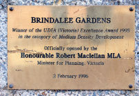
Brindalee
Gardens, Chadstone Housing Develpment – 1996. |
A
brass-plated plaque with black recessed lettering. |
Brindalee
Mews, off Bolwarra St, Chadstone – north of Waverley Rd,
west of Huntingdale Rd.
The plaque is located in the centre parkland of
the estate.
|
69J2
|
BRINDALEE GARDENS
Winner of the
UDIA (Victoria) Excellence Award, 1995 in the category of
Medium Density Development
Officially
opened by the Honourable Robert Maclellan MLA
Minister for
Planning, Victoria
2
February, 1996
|
Note,
21/3/2008:
The plaque is of coated brass and has some superficial
damage.
Located
to commemorate the opening of the medium density estate
on the site of the former Jordanville South Primary
School.
Note, 9/6/2008:
Brindalee Gardens, Chadstone
1992 – 1995
UDIA Award
|
 |
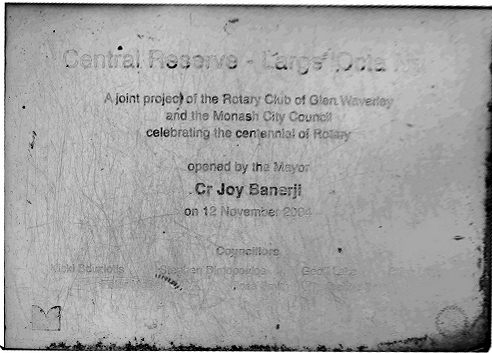
Cenotaph
& War Memorial, Glen Waverley, – c.1920. |
A large,
granite monument containing inscriptions on all four
faces. |
Springvale
Rd, Glen Waverley, west side, south of Waverley Rd.
Central Reserve. |
71C5
|
EAST FACING FACADE:
FOR KING AND
COUNTRY
ERECTED AS A
TRIBUTE TO THE MEN OF GLEN WAVERLEY WHO MADE THE SUPREME
SACRIFICE IN THE GREAT WAR
1914-1918
THEIR NAME
LIVETH FOR EVERMORE
NORTH FACING
FACADE:
LAW F.
SMITH N
.WHEELWRIGHT H.M.
WEST FACING
FACADE:
LEST WE FORGET
SOUTH FACING
FACADE:
ADAMS, F.
FEAR S.R.W.
HERRIOT W.E.
HORNER C.S.C.
|
Historical
note, 9/3/2008:
The cenotaph is dedicated to the memory of those
men of the Shire of Mulgrave/ City of Waverley who made
the supreme sacrifice during World War I and World War
II,
|
 |
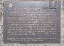
Cheshire
Cheese Hotel Wheelers Hill (1864) – 1985. |
A bronze
plaque with raised bronze lettering set into the concrete
footpath. |
Ferntree
Gully Rd, north side west of Lum Rd, Wheelers Hill.
Note: 10/2/2008
– right on the corner of Lum Road, west side.
|
71F9
|
THE CHESHIRE CHEESE 1864
In the eighteen
sixties a number of rudimentary inns were established
throughout the district. One of the earliest was The
Cheshire Cheese built here by Robert Wolstenholme with
locally cut sandstone. It soon became a staging for Cobb
and Company and catered successfully for settlers, timber
sawyers, bushmen and travelers. Other early inns
were the Notting Hill, The Mulgrave Arms, The Tally Ho
and The Mountain View, The Squatters Rest, known also as
The No Good Damper, The South Yarra and The Lady Of The
Lake. So elegant was this stone that the Anglicans
accepted Wolstenholme’s offer to donate what he did not
need to construct the beautiful St Matthew’s Church on
Wellington and Springvale Roads corner in 1869. It
stood proudly until demolished in 1976.
Placed as part
of the Victoria 150 celebrations in the City of Waverley
by the Council, Spring, 1985
|
VICTORIA 150 CELEBRATIONS
Historical note,
10/2/2008:
This hotel was built from local sandstone and later
became known as the Temperance Hotel. Lum Rd was
named after the family who built their wattle and daub
home there.
Existed from 1864,
but in 1885 was delicensed and became the home of John
brown, from Heidelberg. In 1891 the Cheshire cheese
became George Cotter’s Temperance Hotel.
|
 |
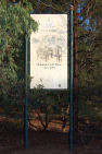
City of
Waverley History Series, Glen Waverley |
A large board
to commemorate the finding of gold in the creeks around
the Mountain View Hotel in 1893. |
Springvale
Road, north west corner of intersection with High Street
Road. It faces south. |
62D2
|
CITY OF WAVERLEY
HISTORY SERIES
HOLLAND’S GOLD
MINE
Circa 1893
Gold was
discovered on this site, previously known as Black Flat
in 1893, mining continued on into the turn of the
century.
|
NOTE,
21/2/2008:
This board is one of three of a series which was
erected. One other is known but has since been
removed:
Cnr.
Waverley and Springvale Rds – south side Waverley Rd,
east of the Bowling Club.
This commemorated the
original site of the Black Flat township.
Also the site of the
Holland brothers mine. Little gold was actually found.
Note: 9/3/2008.
Re: condition. The sign is fading and is showing the
signs of weathering.
|
 |
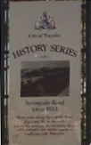
City of
Waverley History Series, Glen Waverley |
A large board commemorating the once rural aspect of Springvale
Road, Glen Waverley. |
Originally
placed near the corner of Springvale and Waverley Roads
on Central Reserve. |
71C5
|
CITY OF WAVERLEY
HISTORY SERIES
Springvale
Road (circa 1920)
Rural scene
along Springvale Road depicting life in the early part of
the century, the available shops amid orchards and market
gardens typifying early Waverley.
|
NOTE, 18
June, 2008:
This
is one of three such history of Waverley signs
placed. However, this has since been removed from
its position near Central Reserve and its whereabouts is
not known.
|
 |
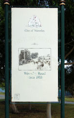
City of
Waverley History
Series, Glen Waverley |
A large board
to commemorating the once rural aspect of Waverley Rd,
Mt. Waverley. |
Cnr Waverley
Rd and Pamela St, east corner, facing Waverley Rd. |
70C3
|
CITY OF WAVERLEY
HISTORY SERIES
WAVERLEY ROAD
CIRCA 1933)
|
Note,
21/2/2008:
Commemorating the once-rural aspect of Waverley Road.
This photo was typical of all main roads within the Shire
of Mulgrave until the coming of the urban population in
the 1950s and 1960s. The photograph shows Park Lane on
the left and cows, probably belonging to Goffs wandering
on Waverley Rd.
There
would have been text below the photo, however this has
faded and disappeared over time. Original text unknown at
this time.
Note, 21/2/2008:
This board is one of three of a series which was
erected. One other is known but has since been
removed. :Cnr. Waverley and Springvale Rds – south side
Waverley Rd, east of the Bowling Club. This commemorated
the original site of the Black Flat township.
Note, 21/2/2008:
Re: condition. The sign is fading and is showing the
signs of weathering.
|
 |
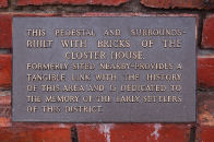
The Closter
Family Home, Mt Waverley (1900) – c.1978. |
A bronze
plaque with raised, bronze lettering. |
Located at
the entrance to Community Centre, Miller Cres, Mt.
Waverley, north side, between Stephensons Rd and Wadham
Parade. |
61E1
|
THIS PEDESTAL AND SURROUNDS
BUILT WITH
BRICKS OF THE
CLOSTER HOUSE,
FORMERLY SITED
NEARBY – PROVIDES A
TANGIBLE LINK
WITH THE HISTORY
OF THE AREA
AND IS DEDICATED TO
THE MEMORY OF
THE EARLY SETTLERS
OF THE
DISTRICT.
|
Note,
10/2/2008:
The plaque is set in a base constructed from Blackburn
pressed bricks from the 1900 home.
The plaque provides no
dates or information about who placed it and when.
(Probably erected after 1978)
Original bronze
sundial has been vandalized or removed from the top of
the pedestal.
George and Rosina
Closter (formerly Kloster) lived and farmed in
Stephensons Road and their house was burnt down, to be
replaced in 1900. This was built on Stephensons Rd
between Miller Crescent and Holskamp St. After
their deaths, Waverley Council purchased the home and it
was demolished in 1978.
|
 |
Cook Family
Property and home, Glen Waverley (1919) – 1988. |
A bronze
plaque with raised bronze lettering. |
The plaque
mounted in the Glen Waverley Library forecourt, Kingsway,
Glen Waverley – east side, close to road. |
71C3
|
THE COOK FAMILY
This plaque
marks the site of the former Cook family cottage. In
1919, on his return from the war, Philip Everard Cook
purchased, with assistance from his brothers Leonard and
Bertram 10 acres of land on which the Civic Centre now
stands. In 1920 Philip established a poultry farm on the
property. He and his brothers and later his mother and
sister became actively involved in the community and
development of the district.
Placed on
“Australia Day” 26 January in the Bicentennial
Year of 1988
Cr. G. B.
Frecker JP Mayor
|
AUSTRALIA’S
BI-CENTENNARY, 1788-1988
Note: 20/2/2008:
This plaque was re-located (several times) from its
original position in front of the main entrance of the
Glen Waverley Library, just a few metres to the west to
avoid damage from skateboarders. The raised lettering may
originally have been gold.
Historical note,
20/2/2008:
Philip Everard Cook purchased land facing Springvale Road
in 1919, with the assistance of his two brothers. Here,
they established a poultry farm on land that was to
eventually house the City of Monash Civic Centre.
|
 |
David Doyle
Sculpture, Monash Gallery of Art – 2001. |
A polished
silver plaque with recessed black lettering. |
Entry to the
Gallery via Gallery Place, from Jells Road. Located on
the edge of the ornamental lake to the east of the
pathway and building. |
71J10
|
DAVID DOYLE
Mom and the
two kids – demographically Oz, 2001
Fibreglass and
marine grade paint finish.
On loan
courtesy of the artist.
|
Note,
16/3/2008:
Mom
and the two kids. Demographically Oz by Australian
sculptor David Doyle is the new addition to the MGA’s
sculpture park. Made from fibreglass and measuring around
two metres in height, Mom and the two kids.
Demographically Oz was a finalist entry in The Helen
Lempriere National Sculpture Award in 2001.
|
 |
David Doyle
Sculpture, Monash Gallery of Art – 2001. |
A polished
silver plaque with recessed black lettering. |
Monash
Gallery of Art, corner Ferntree Gully Road and Jells
Road. Entry to the Gallery via Gallery Place, from Jells
Road, or via the Wheelers Hill Library car park, Ferntree
Gully Road.. The sculpture and plaque are located to the
east of the pathway leading to the entrance of the
Gallery. |
71J10
|
DAVID WATERS
The Set,
2005
Cast concrete.
On loan from the artist
|
Note,
16/3/2008:
David Waters completed his Bachelor of Fine Arts at RMIT
University in 1985. Since this time, David has created
public works for various locations across Australia and
his sculptural and print work has been included in over
40 exhibitions. He has won several prizes, including the
2005 Montalto Sculpture Prize. David uses a range of
materials in unconventional ways, such as wood, canvas,
foam, glass and clay to create installation and
sculptural works. |
 |
Directory of
Historic Markers, Glen Waverley Library – 1984. |
A series of
four bronze plaques with raised bronze lettering and set
on a large boulder, cut in half. |
In the
forecourt of Glen Waverley Library, Kingsway, Glen
Waverley, facing north along Kingsway. |
71C3
|
CITY OF WAVERLEY DIRECTORY OF HISTORIC MARKERS
1. THE
BOONOORUNG PEOPLE C.40,000 B.C.
2. THOMAS NAPIER AND MADELINE SCOTT, FIRST EUROPEAN
SETTLERS, 1839
3. THE SCOTCHMANS CREEK RUN, 1840
4. THE TOWN OF “WAVERLEY”, 1854
5. THE TOWN COMMON IN HIGH STREET ROAD, 1861
6. THE TOWN COMMON IN WAVERLEY ROAD, 1861
7. THE CHESHIRE CHEESE AND EARLY INNS, 1864
8. ST. STEPHEN’S CHURCH AND COMMON SCHOOL, 1865
9. THE WESLEYAN CHURCH, BLACK FLAT AND SCHOOL, 1867
10. THE TOLL GATES, 1868
11. SIR REDMOND BARRY’S COUNTRY ESTATE
“SYNDAL”, 1869
.12. THE TALLY HO INN AND RACE TRACK, 1877.
Sites of
Historical Footpath Markers placed as part of the
Victoria 150th Anniversary Celebrations 1984 –
1985.
MAP
A COMMUNITY PROJECT SUPPORTED BY MERCEDES BENZ
(AUSTRALIA) PTY. LTD.
13. THE
MULGRAVE STATE SCHOOL, 1879
14. THE GLEN WAVERLEY STATE SCHOOL, 1880
15. THE BLACKSMITH’S FORGE, BLACK FLAT, 1885
16. THE MULGRAVE PRESBYTERIAN CHURCH, 1891
17. GOLD DISCOVERIES, 1893.
18. HORTY HALL, 1899
19. THE AUTOMOBILE CLUB OF VICTORIA, CAR RALLY, 1905
20. TAIT’S POST OFFICE AND STORE, MT. WAVERLEY, 1905
21. MOUNT WAVERLEY STATE SCHOOL, 1906
22. THE GLEN WAVERLEY MECHANICS INSTITUTE, 1908
23. ST. LEONARD’S CHURCH ORIGINAL SITE, 1913
24. THE OLD SHIRE OFFICES, NOTTING HILL, 1921.
|
VICTORIA 150 CELEBRATIONS
Note, 12/2/2008:
Directory of Historic Markers. Placed in 1984
to mark the placement of 24 markers at various points
within the City of Waverley, it commemorates
Victoria’s Sesqui-centenary. The marker was
donated by Mercedes Benz, Australia and was unveiled by
the then Mayor of the City of Waverley, Cr. Russell
Hannan.
The marker was
donated by Mercedes Benz, Australia and was unveiled by
the then Mayor of the City of Waverley, Cr. Russell
Hannan.
Note, 12/2/2008:
Of the original 24 plaques placed for this project, only
one can be considered to be lost.
No. 13 (The Mulgrave
State school Plaque) disappeared during roadworks along
Wellington Rd at some stage.
|
 |
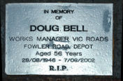
Doug Bell,
Plaque Vic Roads – Mt Waverley – 2002. |
A polished
silver steel plaque with recessed black lettering. |
On the
embankment on the Ferntree Gully Road on-ramp to the
Monash Freeway. Entrance to the on-ramp is from the south
side of Ferntree Gully Road, west of Springvale Road. |
71A8
|
IN MEMORY
OF
DOUG BELL
WORKS MANAGER
VIC ROADS FOWLER ROAD. DEPOT
Aged 56 Years
28/8/1946 – 7/8/2002
R.I.P.
|
Placed to
commemoration the work of Vic Roads manager, Doug Bell.
Note, 21/3/2008.
Access is only
possible by stopping on the on-ramp to the freeway. There
appears to be no access from the southern side of the
embankment.
|
 |
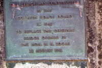
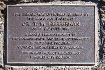
Footbridge
over Blackburn Rd, Mt Waverley – 1990. |
A bronze
plaque with raised, bronze lettering recessed into a
large, honeycomb rock. |
Plaque is
located on the east side of the road at the commencement
of the bridge. North of Stableford Avenue. |
70J3
|
THIS BRIDGE WAS OFFICIALLY OPENED BY
THE MAYOR OF
WAVERLEY
CR. T. M. HEFFERNAN
ON 29 OCTOBER
1990
A JOINTLY
FUNDED PROJECT BY
THE
COMMONWEALTH AND STATE GOVERNMENTS
BICENTENNIAL PROGRAM,
VICROADS AND WAVERLEY CITY COUNCIL.
DESIGN AND PROJECT MANAGEMENT
WAVERLEY CITY COUNCIL.
|
Note:
12/3/2008.
A footbridge to span busy Blackburn Road was built in the
Scotchmans Creek gully in 1990. It connects the
consulting/medical suites to the east of Blackburn Road
with Waverley Hospital and provided a continuous bike
path through Scotchmans Creek Linear Park.
This 11 km path bisects
the municipality into Northern and Southern sections. It
begins at Warrigal Road and intersects with the Dandenong
Creek Path at the picturesque Jells Park. Areas of
interest include sports grounds, Monash Aquatic and
Recreation Centre, Oakleigh Recreation Centre, Glen
Waverley Police Academy, Brickmakers Park, Waverley and
Oakleigh Golf Courses and Monash University.
|
 |
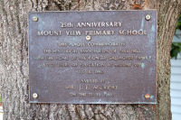
Gallagher
Family Property and Home, Glen Waverley, (1871) – 1990. |
A bronze
plaque with raised bronze lettering. |
Attached to
an Oak tree, in the grounds of Mt. View Primary School,
cnr. Gallaghers and Shepherd Rd, Glen Waverley. |
71F3
|
25th ANNIVERSARY
MOUNT VIEW
PRIMARY SCHOOL
THIS
PLAQUE COMMEMORATES
THE HISTORICAL ASSOCIATION OF THIS TREE WITH THE HOME OF
THE PIONEER GALLAGHER FAMILY AND 25 YEARS OF EDUCATION AT
MOUNT VIEW. 11/10/1990.
UNVEILED BY
MR. J. F. MURPHY
ON THE 21.10.1990.
|
Historical
note, 21/2/2008:
Peter Gallagher selected land along Minogue’s Road (now
Gallaghers Road) in 1871 – 128 acres running east to
Dandenong Creek. He and his wife Rose, built their home
facing the present Shepherd Road where they raised their
family. Descendents were still farming the property when
the Education Department bought the top section of the
land for a school in around 1965. |
 |
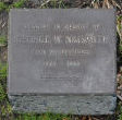
George
Naismith, Club professional, Riversdale Gof Club – 1983. |
Bronze plaque
with raised bronze lettering, mounted on a small, raised
concrete base. |
Riversdale
golf course, beside the pathway leading to the 1st tee,
east side. |
61A11
|
PLANTED IN MEMORY OF GEORGE W. NAISMITH 1928-
1963. DIED 25-5-83
|
Note,
20/2/2008:
Permission should be gained from Riversdale Golf Club to
view.
Note,
9/6/2008:
Shortly after the move to St. Johns Wood, George Naismith
was appointed Professional to Riversdale, a position he
held for some 34 years. A fine golfer, Naismith was
Victorian Professional Champion in 1932 and 1934 and won
the Australian Open in 1937. Apart from his outstanding
golfing record, George Naismith is well known as the
early mentor of two later golfing greats Peter Thomson
and David Graham, both of whom were Assistant
Professionals at Riversdale.
|
 |
Glen Waverley
(Heights) Primary School, Silver Anniversary – 1985. |
A bronze
plaque with raised bronze lettering placed on a honey
comb rock. |
Glen Waverley
Primary School, High Street Road, Glen Waverley, east of
Springvale Road, south side. The plaque is located in the
centre of the school grounds, north of the main buildings
and east of |
71D1
|
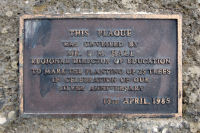
THIS PLAQUE WAS UNVEILED BY MR. I. M. HALL
REGIONAL DIRECTOR OF EDUCATION TO MARK THE PLANTING OF 25
TREES IN CELEBRATION OF OUR SILVER ANNIVERSARY
|
Placed to
commemorate the silver anniversary of the school,
formerly Glen Waverley Heights Primary School. A
stand of trees was planted to mark the occasion in 1985.
Note, 21/3/2008:
Access is restricted. Access at weekends is open, however
during school hours, inquiries should be directed to the
school office.
|
 |
Glen Waverley
Mechanics Institute, (1908) – 1985. |
A bronze
plaque with raised, gold writing set into the concrete
path. |
Springvale
Road, Glen Waverley, west side, south of Waverley Road,
adjacent to, and to the south of the main entrance to
Central Reserve. |
71C5
|
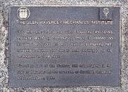
THE GLEN WAVERLEY MECHANICS INSTITUTE
On this site
stood the Glen Waverley Mechanics Institute. Built by
community effort, it opened on August 18th, 1909 and was
used as a meeting hall, committee rooms and library until
destroyed by fire on September 10th, 1956.
Placed as part
of the Victoria 150 celebrations in the City of Waverley
by the students of Caulfield Grammar School, Autumn,
1985.
|
VICTORIA 150 CELEBRATIONS
Note, 10/2/2008:
On October 2,1907,12 men bought ten acres of land in
Springvale Road, to provide an athletics ground. A
Mechanics’ Institute Hall was built on half an acre of
this land and opened on 18 August 1909.
After much community
enthusiasm and physical effort, a recreation reserve was
opened in 1908 and a Mechanics Institute Hall in 1909.
Two front rooms were added in 1926 but the whole building
was destroyed by fire in 1956 when it was being used as a
temporary school room.
|
 |
Glen Waverley
State School, (1880) – 1985. |
Two bronze
plaques with raised, bronze lettering – one a directional
plaque. |
Waverley
Road, north east corner with Springvale Road, Glen
Waverley. The directional plaque is set into the concrete
pathway on Springvale road and the main plaque has been
placed onto the west-facing wall of the school building. |
71C4
|
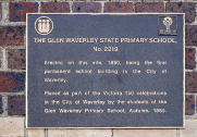
THE GLEN WAVERLEY STATE PRIMARY SCHOOL, No 2219
Erected on
this site, 1880, being the first permanent school
building in the City of Waverley.
Placed as part
of the Victoria 150 celebrations in the City of Waverley
by the students of the Glen Waverley Primary School,
Autumn, 1985.
|
VICTORIA 150 CELEBRATIONS
Historical note,
10/2/2008:
The first school was held in the Wesleyan Chapel which
later became a state school. The new brick school with
residence was built on this corner in 1880 and this
building can still be seen. On the opposite corner was
the site of an early General Store and Post Office.
The building is
currently leased to Le Pine and Sons for use by them and
also as a community meeting place. This current lease
expires in 2009.
|
 |
Glen Waverley
War Memorial – 1999. |
The memorial
consists of three concrete panels joined at the apex.There are plaques on the panels and a polished
black granite plinth on the western (Kingsway) side of
the memorial. |
Located at
the south end of Kingsway, Glen Waverley, east side
between Glen Waverley Library and the Ibis Hotel. |
71C3
|
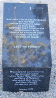
WEST FACING PLINTH:
PASS NOT IN
THIS PLACE IN SORROW BUT IN PRIDE AS MAY YOU LIVE NOBLY
AS THEY DIED KNOWING THAT THEIR DEATH IN FREEDOM’S CAUSE
STANDS AS A BEACON LIGHT TO POINT THE WAY TO PATHS OF
PEACE.
“LEST WE
FORGET” THIS MEMORIAL COMMEMORATES THE MEN AND WOMEN
OF THE FORMER CITY OF WAVERLEY AND SHIRE OF MULGRAVE WHO
SERVED THEIR COUNTRY, AND THOSE WHO PAID THE SUPREME
SACRIFICE.
JANUARY 1999
WORLD
WAR I
1914-1918
ADAMS F.
ALCOCK J.
BARKER F.
BATTEN T.
BENNETT F.T.
BRAY R.L.
BRENNAN W.J.
BROWN S.
CAMPBELL W.
CORNELL E.
CROW W.
DOOLAN W.R.
DOVER T.E.
FEAR S.R.W.
FURPHY A.F.
HERRIOTT W.E.
HORE S.E.
HORNER C.S.C.
KELSELL W.J.
LAW F.
MUNRO A.M.
MCPHERSON A.R.
MCPHERSON L.J.
SMITH N.
WHEELWRIGHT H.M
WHITE D.C.
WORLD
WAR II
1939-1945
COOPER A.D.W.
COVENTRY H.F.
EZZARD R.H.
FEW W.J.
FOSTER B.
FREESTONE T.G.
GREENWOOD L.J.
KERFERD L.G.
MARWICK H.G.
MATTHEWS R.G.
MOORE A.T.
PARKINSON J.
SOMERVILLE J.
VOUSDEN G.V.
WILSON E.R
VIETNAM
1962-1973
DAVIES R.E.
HARTNEY G.J.
WATSON R.C.A
|
Note:
9/3/2008:
This
recently constructed Memorial carries a number of
polished bronze plaques and is dedicated to those locals
who served and died in all wars and conflicts. Erected in
1999.
|
 |
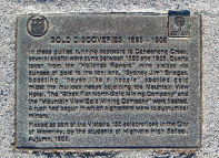
Gold
Discoveries, Glen Waverley (1893) – 1985. |
A bronze
plaque with raised, bronze lettering, set into the
concrete path. |
Springvale
Road, Glen Waverley, west side, north of High Street
Road. |
62D12
|
GOLD DISCOVERIES, 1893 – 1905
In these
gullies running eastward to Dandenong Creek, several
shafts were sunk between 1893 and 1906. Quartz taken from
the “Hollands Reward” mine yielded six ounces
of gold to the ton. “Sydney Jim” Bridges,
boasting “heyes like a heagle” spotted gold
midst the mullock heaps adjoining the Mountain View
Hotel. The “Black Flat North Gold Mining
Company” and the “Mountain View Gold Mining
Company were formed. A rush had begun in which sightseers
were to outnumber miners.
Placed as part
of the Victoria 150 celebrations in the City of Waverley,
by the students of Highvale High School, Autumn, 1985.
|
VICTORIA 150
CELEBRATIONS
Historical note,
10/2/2008:
Gold was first
discovered near the Mountain View Hotel by a digger named
James Bridge. Phillip Holland and his sons obtained gold
from the reef near the hotel. The Mountain View
Hotel, now modernised, has functioned since 1877.
|
 |
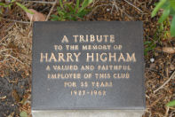
Harry Higham,
Riversdale Golf Club – 1982. |
A small
bronze memorial plaque with raised bronze lettering. |
Located in
the grounds of Riversdale Golf Course, entrance from
Huntingdale Road. Located adjacent to the 3rd tee. |
61A11
|
A TRIBUTE
TO THE MEMORY
OF
HARRY HIGHAM
A VALUED AND
FAITHFUL
EMPLOYEE OF
THIS CLUB
FOR 35 YEARS
1927-1962
|
Note,
20/2/2008:
Permission to view should be gained from Riversdale Golf
Club.
Biographical
note, 4/6/2008.
Harry Higham, 1890-1962.
Harry Higham was born
on May 27th, 1890 in Lancashire England. he lived first
at Blackpool. At the age of 10, he left school to earn
his living and help support his widowed mother.
In the following
years he worked in the market gardens around Blackpool,
before coming out to Australia in 1911, at the age of 21.
In Australia he
worked on the land, mainly in market gardens around
Melbourne. During World War I he served in the Merchant
navy and on hospital ships between India and the Middle
East.
On the 29 March 1919,
he married Jessie Brewer, daughter of James Brewer, the
owner of St. John’s Wood, now Riversdale Golf Links.
When St. John’s Wood
was sold to Riversdale, he stayed on, helping lay out the
course and then as greenkeeper, took charge of the course
and grounds until ill-health forced him to retire many
years later.
During those years as
greenkeeper he also planted most of the trees at
Riversdale and also laid out and cared for the gardens in
front of the club-house, always a delight to see.
When the bowling
green was laid out, he took over its care and
maintenance, leaving most of the other course duties to
his assistants.
On many an occasion
in hot weather, he would make a special trip over the
weekend to hand water his bowling green. Ill health
forced his retirement and he died on September 24, 1962.
A small memorial
plaque is under a silver birch tree beside his beloved
bowling green.
M.J.W.
Written by his daughter,
Mary (Higham) Wolf in Adelaide, S.A.
|
 |
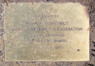
Highvale
& District Guide and Brownie Association Plaque &
Seat – 1988. |
A small brass
plaque with recessed lettering. |
Westlands
Road, Glen Waverley, east side, in front of number 40,
Westlands Road. Placed on the nature strip and surrounded
by a small concrete base, adjacent to the street seat. |
62F2
|
DONATED BY HIGHVALE DISTRICT GUIDE AND BROWNIE
ASSOCIATION COMMEMORATING THE BICENTENNIAL 25 JUNE 1988.
|
AUSTRALIA’S BI-CENTENNARY, 1788-1988.
Note, 17/3/2008:
The plaque is showing signs of scratching on the surface.
Located to mark the
installation of a street seat marking the occasion of the
country’s Bicentennial, 1988.
|
 |
Horticultural
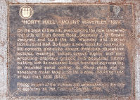
“Horty” Hall, Mt Waverley, (1899) – 1985. |
A bronze
plaque with raised bronze lettering and set into the
footpath. |
High Street
Road, south side, cnr Stewart Street, Mt. Waverley.
Note: 13/2/2008. Located
in front of 486 High Street Road.
|
61H12
|
“HORTY HALL”, MOUNT WAVERLEY, 1899.
On the crest
of this hill, over-looking the now renowned orchards of
High Street Road, Secretary J. B. Brewster designed and
built the Mt. Waverley and District Horticultural Hall.
So began a new focus for community life: concerts, glee
clubs, dances, theatricals, educational lectures,
meetings, schools, speech nights, and even wrestling
displays graced this beautiful timber building with its
rusticated block fronted and iron cresting, its moulded
panel ceiling, its Kauri seats and its handsome nickel
lamps for a cost, including land of less than £200,
($400).
Placed as part
of the Victoria 150 celebrations in the City of Waverley
by the Council, Spring, 1985.
|
VICTORIA 150 CELEBRATIONS
Historical note
13/2/2008:
The Mt. Waverley and District Association had been part
of the Boorondara, Nunawading and Mulgrave Horticultural
and Fruitgrowers Association.
Built for the staging
of horticultural shows,’Horty Hall’ became a focus for
community life – concerts, dances, meetings, etc. Known
locally as “Horty Hall”. Now demolished.
Joshua Brand
Brewer had lived at “St. John’s Wood”,
previously connected with Sir Redmond Barry and his
mistress, Louisa Barry.
|
 |
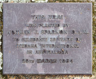
Ikebana
International Plaque & Tree, Jells Park – 1984. |
A bronze
plaque with raised lettering (may originally have been
bronze). |
The grounds
of Jells Park, beside the walking track approximately 150
metres north-east of the Visitors’ Centre – Cafe.
Located at ground level beneath a tree planted in 1984. |
71K6
|
THIS TREE WAS PLANTED BY
NORMAN J.
SPARNON O.A.M.
TO CELEBRATE
25 YEARS OF IKEBANA INTERNATIONAL IN AUSTRALASIA
29TH MARCH
1984
|
The plaque
commemorates 25 years of Ikebana International in
Australia.
Note,
21/3/2008:
IKEBANA is the Japanese art of flower arrangement.
IKEBANA is more than simply putting flowers in a
container. It is a disciplined art form in which the
arrangement is a living thing in which nature and
humanity are brought together. It is steeped in the
philosophy of developing closeness with nature.
As is true of all
other arts, IKEBANA is creative expression within certain
rules of construction. Its materials are living
branches, leaves, grasses, and blossoms. Its heart is the
beauty resulting from colour combinations, natural
shapes, graceful lines, and the meaning latent in the
total form of the arrangement. IKEBANA is, therefore,
much more than mere floral decoration.
The growing
appreciation of Japanese art and architecture in the West
has extended to the Japanese way with flowers. IKEBANA is
an art, in the same sense that painting and sculpture are
arts. It has a recorded history; it is backed up by
articulate theories; and it is concerned with
creativity. In Japan, flower arrangements are used
as decorations on a level with paintings and other art
objects.
|
 |
Inge King
Sculpture, Monash Gallery of Art, – 1998. |
A polished,
silver plaque with black, painted letters. |
Gallery of
Monash, corner of Ferntree Gully Rd and Jells Road. Entry
to the Gallery via Gallery Place, from Jells Rd or via
the Wheelers Hill Library car park, Ferntree Gully Rd.
The sculpture is located to the right of the pathway to
the Gallery entrance. |
71J10
|
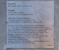
INGE KING
Born Germany,
1918, arrived Australia, 1951.
NAYADS
1997,
Warrandyte, Melbourne.
Purchased
through the Art Foundation of Victoria with the
assistance of J. B. Were and Sons, Governors, 1997.
Inge King was
born in Berlin in 1918. She commenced formal studies at
The Academy of Fine Arts in Berlin and later was awarded
a scholarship to study at The Royal Academy in London.
After studying there for one year she enrolled at the
Glasgow School of Art, where she graduated and joined the
teaching staff. She also studied in Paris and in New
York. Before arriving in Australia in 1950, she held an
exhibition at the London Gallery, Brooke Street.
In Australia,
Inge King became a foundation member of the Centre Five
group. Other members include, Julius Kane, Clifford Last,
Lenton Parr, Vincas Jomantus, Teisutis Zikaras.
Inge King is
represented in public and private collections in
Australia and overseas and is best known for her many
public commissions.
1998
|
To mark the
external sculpture by Inge King.
Note, 16/3/2008:
Inge King – b. 1929, lives in Warrandyte, Victoria.
In her early sculpture King worked with a variety of
materials, although the modern media of arc welding and
industrial steel characterize most of her work after
1960. King’s geometric abstractions challenge the viewer
to explore the formal relations of space in and around
her work and to consider the figurative allusions made in
her titles. When Inge King executes monumental projects,
such as Surge Forward, she works with a team of engineers
and welders to enlarge and install her Marquettes.
|
 |
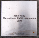
John Kelly,
Sculpture Monash Gallery of Art, – 2003. |
A brushed
aluminium plaque below the rusted metal sculpture. |
Gallery of
Monash, corner of Ferntree Gully Rd and Jells Rd. Entry
to the Gallery via Gallery Place, from Jells Road, or via
the Wheelers Hill Library car park, Ferntree Gully Rd.
The sculpture is located close to the entrance to the
Wheelers Hill Library car park, Ferntree Gully Rd. |
71J10 |
JOHN KELLY
Marquette for
a public monument
2003
rusted corten
steel 3/3
on loan
courtesy of the artists and Niagara Galleries
|
Note,
21/3/2008:
The English born sculptor John Kelly grew up in Australia
but is now living in Ireland. It’s not the first
unusual or exotic location for a John Kelly sculpture.
His previous exhibits include Cow up a tree (which
featured in The Times) at the Les Champs de la Sculpture
(1999) on the Champs Elysees, Paris. The public debut of
Three cows in a pile was at La Parade des Animaux, in the
Casino Gardens in Monte Carlo in 2002. Both Cow up a tree
and Three cows in a pile were cast at the famous
Courbetin Foundry, Paris.
In 1994 John Kelly was awarded a residency at
the Australia Council studio in Barcelona which was
followed in 1995 by an exhibition of his work Piccadilly
Gallery in London. In late 1996 he received a twelve
months Samstag Scholarship to study at the Slade, London.
The Samstag Scholarship was crucial in allowing him to
live and work in London.
|
 |
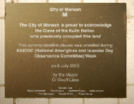
Kulin Nation
Plaque, Civic Centre – 2002 |
A brass
coloured plaque with white lettering. |
Located at
the entrance to City of Monash Civic Centre, Springvale
Road, Glen Waverley. Fixed to the wall on the left of the
main entrance. |
71C3
|
City of Monash
The City of
Monash is proud to acknowledge the Clans of the Kulin
Nation who previously occupied the land
This
commemorative plaque was unveiled during NAIDOC (National
Aborigines and Islander Day Observance Committee) Week
On 8 July 2002
by the Mayor
Cr Geoff Lake
Councillors
Peter Holdsworth Paul Klisaris Matthew Evans Kathy
Magee Tom Morrissey Felicity Smith Peter Vlahos
|
Placed to
honour the indigenous inhabitants of this region prior to
European settlement.
Historical Note, 9/6/2008:
About The Wurundjeri People:
The Kulin nation comprised a number of clans and the Woi
wurrung and more specifically, the Wurrundjeri hunted and
lived in the area we now know as the City of Monash.
The first people that
occupied the Melbourne area prior to European
colonisation were the Woiwurrung language group,
specifically the Wurundjeri people.
The following is a
list of the clans within the Wurundjeri area:
Wurundjeri-balluk
& Wurundjeri-willam (Yarra Valley Yarra River
catchment area to Heidelberg)
Balluk-willam (south
of the Yarra Valley extending down to Dandenong,
Cranbourne, Koo-wee-rup Swamp)
Gunnung-willam-balluk
(east of the Great Dividing Ranges and north to
Lancefield) Kurung-jang-balluk (Werribee River to
Sunbury) Marin-balluk (Boi-berrit) (land west of the
Maribyrnong River and Sunbury) Kurnaje-berreing (the land
between the Maribyrnong and Yarra Rivers)
Boundaries
The territory of the Wurundjeri lies within the inner
city of Melbourne and extends north of the Great Dividing
Ranges, east to Mt Baw Baw, south to Mordialloc Creek and
west to Werribee River.
Language /
terminology
Some key terms of Woiwurrung language (and their English
equivalent) are noted here:
Bulluk / balluk –
swamp
Nira – cave
Willam / wilam /
Illam / yilam – hut, camp, bark Gunung / Gunnung – River
Totems :
The two moeity totems of the Wurundjeri people are Bunjil
the Eaglehawk and Waang the Crow.
Places of
Significance
The Wurundjeri are the traditional owners of a large part
of the land of inner and outer Melbourne.
The Yarra River was
central to the Wurundjeri people as it provided a variety
of foods such as eels and fish. Along its fertile banks
the numerous variety of native animals and plants would
be found.
There are a number of
identified significant sites, in particular those found
near the Yarra & Maribyrnong Rivers and the Merri
Creek. A place of great gathering occurred at the Bolin
Bolin Billabong in Bulleen where sacred and social
interaction between the clans would take place. The
Wurundjeri would also gather with other members of the
Kulin Nation on the land where the Melbourne Cricket
Ground (MGC) now stands. Other places of significance for
the Wurundjeri people are:
Coranderrk Mission
Station (Healesville)
Pound Bend
(Templestowe / Doncaster)
Mt William Aboriginal
Stone Axe Quarry Dights Falls area (Collingwood)
Heide Scarred Tree
(Templestowe)
The Sunbury Rings
(Sunbury)
Featuring prominently
in Wurundjeri story is William Barak, the last
traditional great Ngurungaeta or leader of the clan, who
witnessed the signing of the ‘treaty’ between Woiwurrung
and Boonerwrung Elders and John Batman. The Ngurungaeta
of the Wurundjeri clan at that time was his father
Bebejern, from whom Barak inherited the title.
|
 |
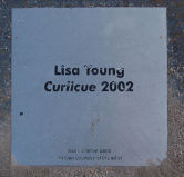
Lisa Young
Sculpture, Monash Gallery of Art – 2002. |
A silver
metal plaque with black lettering. |
Monash
Gallery of Art, corner Ferntree Gully Road and Jells
Road. Entry to the Gallery via Gallery Place, from Jells
Road, or via the Wheelers Hill Library car park,
Ferntree Gully Road. The sculpture is located immediately
to the left of the path leading to the entrance to the
Gallery and in front of the building. |
71J10
|
LISA YOUNG
Curlique 2002
steel, paint
on loan from
the artist
|
Note,
16/3/2008:
Lisa
Young’s focus is the core elements of transportation, the
mechanical units that work in unison to propel and create
movement. She has interpreted a variety of cogs, gears,
pulleys, levers, wheels, axles, and circuitry to create
inventive prototypes for phantasical, meandering
mechanics. Illustrating driving forces behind motion;
velocity, cause/effect and momentum.
|
 |
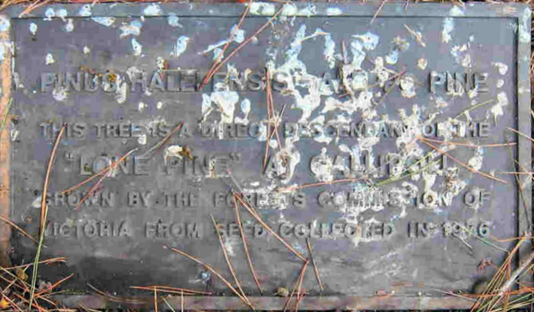
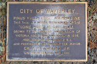
Lone Pine
Plaque, Glen Waverley – 1981 |
A bronze
plaque with raised, bronze lettering set on a honeycomb
rock. |
Springvale
Road, Glen Waverley, west side, south of Waverley Road.
Central Reserve. To the north of the Memorial Gates and
Cenotaph. |
71C5
|
CITY OF WAVERLEY
PINUS
HALEPENSIS – ALLEPO PINE
THIS TREE IS A
DIRECT DESCENDENT
OF THE “LONE PINE” AT GALLIPOLI.
GROWN BY THE FORESTS COMMISSION OF
VICTORIA FROM SEED COLLECTED IN 1976.
PRESENTED BY WAVERLEY R.S.L.
AND PLANTED BY
HIS WORSHIP THE MAYOR
CR V.P.
LeGRAND J.P.
ON
REMEMBERANCE DAY, 1981
|
The Pine tree
was planted in 1981 and is a direct descendent of the
original Lone Pine at Gallipoli and grown in
Victoria.
Historical
note, 9/6/2008:
THE BATTLE OF LONE PINE:
Lone Pine was one of
the three attacks planned in order to create a diversion
for a British landing in Suvla Bay, and was carried out
by the 1st Division, which consisted of the 1st, 2nd, and
3rd Brigades. At 5:30 pm on August 6th, 1915 these men
attacked when the sun was at their backs, and in the
Turkish eyes.
The first wave of men
were astonished to discover that their objective, being
the Turkish frontline, was completely covered in logs and
earth. This gave the Turkish soldiers the opportunity to
fire safely from a point blank range, and made entry for
the Australians nearly impossible. C.E.W Bean, who was
observing this scene from the Australian trenches,
described the soldiers as “a crowd not unlike that
lining the rope around a cricket field”. However it
wasn’t long before the men began to enter the
communication trenches which were connected to the front
trench allowing them to join their comrades who had
dragged off the heavy log cover at the front.
Wave after wave of
Australians continued to enter the dark and deadly
trenches that were crammed full of dying and fighting
men. Because the fighting was so close, there was no room
to use a bayonet or throw bombs. Instead, hands and the
swords from the bayonets were the substitute weapons.
By six pm the same
day the trenches were taken, but the ANZACs defended and
endured the Turkish counter attacks on their former
trenches for five days, eventually gaining complete
control of the Lone Pine objective.
During the attack,
many men ran over the top of the Lone Pine trenches to
discover massive amounts of Turkish reinforcements
waiting in the depression behind the font line. However
they never lived to tell the tale as they were killed
instantly. In 1920 these bodies were found and were
commemorated on the Lone Pine Memorial dedicated to the
missing.
|
 |
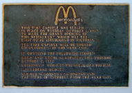
McDonalds
Family Restaurant, Glen Waverley, Time Capsule – 1973. |
A time
capsule and bronze plaque with raised, bronze letters. |
Corner of
High Street Road and Springvale Road – south east
corner. The plaque is located inside the window on the
west side of the building. |
71D1
|
McDONALDS.
THIS TIME
CAPSULE WAS SEALED IN PLACE ON TUESDAY, OCTOBER 2, 1973,
TO MARK THE GRAND OPENING OF THIS RESTAURANT, WHICH WAS
THE FIRST TO BE ESTABLISHED IN VICTORIA.
THE TIME
CAPSULE WILL BE OPENED ON OCTOBER 2, 2000.
IT CONTAINS
THE FOLLOWING ITEMS:-
DAILY AND
LOCAL NEWSPAPERS FOR TUESDAY, OCTOBER 2, 1973.
CURRENCY:
COINS TO THE VALUE OF A BIG MAC.
1973 FEDERAL
BUDGET.
VARIOUS
MCDONALDS EQUIPMENT AND THE ITEMS OF INTEREST FROM THE
YEAR 1973.
|
Note:
17/3/2008.
Placed
in 1973 to commemorate the opening of the first McDonalds
Fast Food outlet in Victoria. The plaque was originally
located in the garden bed on the west side of the
building in 1973. Because it is now in a different
location and inside the building, it may be assumed that
when the time capsule was lifted in 2000 as stated on the
plaque, it may have then been re-placed in its current
position at that point.
Alternatively, it may
have been located in its present position when
remodelling and refitting was done on the restaurant
c.2007.
|
 |
Memorial
Gates & Plaques, Glen Waverley – 1949. |
Memorial
Gates & Plaques, Glen Waverley – 1949. |
Springvale
Rd, Glen Waverley, west side, south of Waverley Rd.
Central Reserve. |
71C5
|
NORTH PILLAR:
R.A.N. Stoker
II COOPER, A.D.W.
R.A.N. Stoker WILSON, B.R.
VX 59470 Cpl. EZZARD, R.H.
VX 35404 Private FEW, W.I.
NX 37837 L/BDR. GREENWOOD, L.J.
VX 8335 Private KERFORD, L.G.
VX24372 Private MARWICK, H.G.
V29032 Private MATTHEWS, R.G
SOUTH PILLAR:
THESE MEMORIAL
GATES
WERE ERECTED IN MEMORY OF THOSE WHO MADE THE SUPREME
SACRIFICE IN THE GREAT WAR 1914 – 1918.
|
Note:
9/3/2008.
The
two bronze plaques are mounted on the two supporting
Lilydale sandstone pillars, both facing east. They were
erected in 1949 to serve as the original entrance to the
War Memorial. Dedicated to those who died in World War I.
They replaced gates which deteriorated and required
replacement.
|
 |
Stained Glass
Windows old St Stepehens Church Mt Waverley – 1959. |
Three stained
glass windows containing memorial information. |
High Street
Road, Mt. Waverley. Entrance from Norma Crt. |
61D11
|
WINDOW 1:
TO THE GLORY
OF GOD AND IN LOVING MEMORY OF MALVINA COLEMAN SHE LIVED
TO SERVE
GIVEN BY HER
HUSBAND AND SON. DEDICATED BY FREDERICK WALDERGRAVE HEAD
ARCHBISHOP OF MELBOURNE. OCTOBER 1ST 1959.
WINDOW 2:
TO.THE.GLORY.OF.
GOD AND.IN.THE.
MEMORY. OF.THE.PIONEERS
.OF.THIS.CHURCH
DEDICATED.BY.THE.
RIGHT.REV.J.J. BOOTH
AUGUST 11TH.1940
WINDOW 3:
THOSE.WHO.GAVE
THEIR.LIVES
J.ALCOCK.
B.ATKINSON.
F.T.BENNETT.
E.CORNELL.
W.R.DOOLAN.
S.E.HORE.
THOSE.WHO.
SERVED.
K.C.BENNINGTON.
C.CORNELL.
L.R.DUNIZE.
H.R.HORE.
W.MUNYARD.
R.B.SMITH.
J.J.TURNER.
BRYCE-PEARCE.
TO.THE.GLORY.OF.GOD.&.IN.HONOUR.OF.THE.MEN.OF.ST.STEPHENS
CHURCH.MOUNT.WAVERLEY.WHO.SERVED.AND.
SOME.WHOM.MADE.THE.SUPREME.SACRIFICE.DURING
.THE.GREAT.WAR.1914-1919
PRO.DEO.PRO.ECCLESIA.PRO.PATRIA.
|
Note,
6/3/2008:
Permmision
to view should be gained from St Stephens Church.
Old St. Stephens was
the first church built in Waverley and is now the oldest
standing church building in Waverley. It is built from
hand-made bricks and contains three memorial windows
dedicated to pioneers of the district and those who
served in World War I.
|
 |
Mimosa
Primary School, Glen Waverley, Past Principals – 1994. |
A mahogany
stained timber board with gold painted lettering. |
Now held at
Waverley Historical Society clubrooms. Passed on to WHS
by past caretaker, Norm Barry. |
70E1
|
MIMOSA PAST PRINCIPALS
1973-6 F.T.
Holmes
1977-8 D.R. Williams
1979 N.M. Ainsworth
1980-3 R.A Crawford
1988- B.G. Gosling (Acting)
1989-94 J.G. Ragas
MIMOSA PRIMARY
SCHOOL VOLUNTARILY CLOSED ON 22-12-94
|
Note,
5/11/2008:
Listing all principals of the school from 1973 to 1994.
This plaque, along with other memorabilia was donated to
Waverley Historical Society by Mr. Norm Barry, former
caretaker of the school.
Originally hung near the school office.
He added a small
engraved metal plaque:
Donated by the Barry Family
|
 |
Mimosa
Primary School, Glen Waverley, opeing of teh school –
1973 |
A silver
steel plaque with recessed, white letters. |
Now held by
the Waverley Historical Society and housed in the rooms,
Miller Cres, Mt Waverley |
70E1
|
MIMOSA PRIMARY SCHOOL
THIS SCHOOL
WAS OFFICIALLY OPENED ON THE 27TH DAY OF OCTOBER, 1973 BY
MR. G.P. HAYES, M.P.
|
Note,
9/4/2008:
The plaque was removed on the closure of the school and
kept safely until handed to Waverley Historical Society
for safekeeping.
Originally placed at the school to commemorate
the official opening of the school in 1973.
|
 |
Morrie Silk
Memorial & Plaque, Riversdale Golf Club – 2001 |
A bronze
memorial plaque with bronze lettering mounted on a
sandstone pedestal. |
It is located
in the grounds of Riversdale Golf Course, entrance from
Huntingdale Road.
On the north side off the third tee just near
pathway.
|
61A11
|
IN MEMORY OF
MORRIE SILK
CAPTAIN
1988 – 1990
PRESIDENT 1998
– 1999
THE RIVERSDALE
GOLF CLUB
FOUNDATION
2001
|
Note,
20/2/2008:
Permission
to view should be gained from Riversdale Golf Club.
Placed in 2001.
Note, 9/6/2008:
Morrie Silk was club captain and president of Riversdale
Golf Club between the years 1988 and 1999. He died in
December 1999.
Morrie Silk was the
father of police officer Sergeant Gary Silk who, with
Senior Constable Rod Miller was shot during a robbery
stake-out at Moorabbin on August 16, 1998.
|
 |
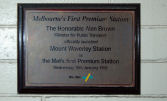
Mt. Waverley
Railway Station, Premium Station – 1995. |
A silver
metal plaque with recessed, black letters mounted on a
rectangular, timber base. |
The plaque is
fixed to the wall to the right of the ticket office, at
the waiting room and entrance to the south platform,
entry from Hamilton Place. |
70E2
|
Melbourne’s First Premium Station
The honourable
Alan Brown
Minister for Public Transport
Officially
launched Mount Waverley Station as the Met’s first
Premium Station
Wednesday, 18
January, 1995
The Met
|
Note,
21/3/2008:
Erected
to commemorate the opening of the new rooms at Mt.
Waverley station as Melbourne’s first Met Premium
Station.
|
 |
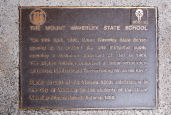
Mt. Waverley
State School, (1906) – 1985. |
A bronze
plaque with raised, gold letters set into the footpath. |
Park Lane,
Mt. Waverley, west side south of William St.
Note: 13/2/2008: located
directly opposite the intersection of Park Lane
with Kemp Avenue.
|
70D3
|
THE MT. WAVERLEY STATE SCHOOL
“On 24
April, 1906, Mt. Waverley State School opened on its
present site with thirty-five pupils, reaching a maximum
enrolment of 1141 in 1968. The original building
comprised a timber schoolroom and porch, the first Head
Teacher being Mr. Jonas Key.”
Placed as part
of the Victoria 150 celebrations in the City of Waverley
by the students of Mt. Waverley Primary School, Autumn,
1985.
|
VICTORIA 150 CELEBRATIONS
Historical note,
13/2/2008:
By 1901, there was mounting pressure by locals in the
central part of the shire to have a school, but a
suggested site to be donated by John Peggie was rejected.
In 1904 another
deputation successfully persuaded the education minister
to act and two acres of Closter’s back paddocks was
obtained. Five years later overcrowding caused lessons to
be taken in the shelter shed.
In 1905, on a two
acre site donated by residents, the Education Department
built a school. A new room was added in 1912.
By the time
extensions were being done in early 1914, some classes
were being taught at nearby ‘Horty’ Hall. From 1953
the population increased until there were 1141 children
on the roll in 1968.
Note: 15/10/2008. The
laneway which once led from Waverley Road, north to the
school can still be seen.
Note 2/12/2008:
New buildings on the site were completed during the last
term of 2008.
|
 |
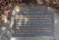
Mulgrave
Presbytarian Church, Wheelers Hill (1891) – 1985. |
Mulgrave
Presbytarian Church, Wheelers Hill (1891) – 1985. |
Ferntree
Gully Rd, north side, west of Lum Road, Wheelers Hill.
Note: 10/2/2008.
On the footpath
directly in front of the old hall.
|
71F9 |
PRESBYTERIAN CHURCH
The Mulgrave
Presbyterian Church was opened on the 19th July 1891 by
Reverend A. Yule. On this day, two services were held
with one hundred and fifty people attending each. The
cost of the building amounted to £173.18.2
Placed as part
of the Victorian 150 celebrations in the City of Waverley
by the students of the Wheelers Hill High School, Autumn,
1985.
|
VICTORIA 150 CELEBRATIONS
Historical note,
10/2/2008:
Opened is 1891 in a small weatherboard hall which still
forms part of the church complex. The old church has been
moved back twice because of a road widening and now forms
a part of a modern complex.
With the decision to
widen Ferntree Gully Rd and create a northern service
road, the old weatherboard building was moved back from
the roadway to its present spot. (Date moved – unknown,
possibly c. 1975-80?)
|
 |
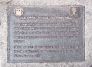
Old Shire
Offices, Notting Hill, (1921) – 1985. |
A bronze
plaque with raised, gold letters set into the footpath. |
Ferntree
Gully Road, Mt. Waverley, south side west of Blackburn
Road.
Note
13/2/2008: Located adjacent to the eastern boundary of
Monash Administrative Offices, 20 metres west of
Blackburn Rd.
|
70G8
|
THE OLD SHIRE OFFICES, (NOTTING HILL)
“This
plaque commemorates the site of the Notting Hill Shire
offices which were on this corner of Ferntree Gully Road
and May Road (now Blackburn Road). The land was purchased
for £400 and the offices opened in 1921.”
Placed as part
of Victoria 150 celebrations in the City of Waverley, by
the students of Monash High School, Autumn, 1985.
|
VICTORIA 150 CELEBRATIONS
Historical note,
13/2/2008:
The establishment of the Shire offices at Notting Hill on
Ferntree Gully Rd had a long history. Moves to move the
Council centre from Oakleigh had been made between 1908
and 1914, but none succeeded. Even the proposal to move
the Oakleigh buildings and the drawing up of plans for a
new building on the site, all failed.
By 1920, it was
revealed that the cost for a Shire building on the
Notting Hill site would cost 12 hundred pounds. Because
of shortages in bricks and timber, progress on the new
building was slow, but the foundation stone was laid in
August, 1920. Power was connected to the building in June
1926.
By 1959, the building
was gone, to be replaced by a petrol station.
|
 |
Original
Waverley Township site, Mt Waverley. |
A polished,
granite stone plaque with recessed lettering. Plus map. |
Located on
the corner Charles and Portsmouth Streets, Mt.
Waverley, (south east corner).
Note: 21/2/2008. Opposite the main entrance to
Avila College, Charles Street.
|
61F12
|
CITY OF MONASH
This site is
part of the original Waverley Township subdivision
created by Dr. J. Silverman in 1854 (refer to plan).
Portions of the original township pattern were lost when
the railway line passed through the area in 1930.
The land
comprised two gullies and stringy bark ranges. A remnant
gully with indigenous vegetation can be found at the High
Street Road/Stephensons Road intersection.
In naming the
area, Dr. Silverman drew upon the novel
“Waverley” by Sir Walter Scott. The large
estate described in the novel comprised pleasant forested
areas and lush gullies. In the novel, Waverley was
associated with, “peace and stability, for social
and political cohesion and harmony.”
The street
names chosen by Dr. Silverman reflected the Jacobite
period of the story. Waverley was the municipalities name
from 1961-1994 and the name is retained in the suburbs of
Mt. Waverley and Glen Waverley.
|
Note,
21/2/2008:
See
also marker 4, south east corner of High Street and
Stephensons Roads.
This site was
originally intended to be the site of a township bearing
the name “Waverley”. Dr. Silverman who bought
the land in 1854 had grand plans. However, the scheme did
not eventuate.
|
 |
Pilot Officer
Bruce Hislop, Riversdale Golf Club – 1941. |
A bronze
memorial plaque with recessed lettering set into the end
of a stone seat. |
Located on
the north side of the time- keepers hut near the 1st tee. |
61A11
|
IN LOVING MEMORY OF
PILOT OFFICER
BRUCE ELWELL HISLOP
KILLED IN AIR
COMBAT ENGLAND
18 SEPT 1941
ERECTED BY HIS
PARENTS & SISTERS
PER AROUA AD ASTRA
|
Note,
20/2/2008:
Permission to view should be gained from Riversdale Golf
Club.
Bruce
Hislop, a member of Riversdale Golf Club was killed on
active duty during World War II.
|
 |
Pilot Officer
Leonard G Sellars, Riversdale Golf Club – 1943 |
A brass
plaque with recessed lettering. |
Located on a
memorial seat in the grounds of Riversdale Golf Course |
61A11
|
Erected by his wife and parents
in loving memory of
Pilot Officer Leonard G Sellars
Killed on active service in England
22 July 1942
|
Note,
20/2/2008:
Permission to view should be gained from Riversdale Golf
Club.
Pilot
Officer Leonard G Sellars, member of Riversdale Golf Club
was killed on active duty during World War II.
|
 |
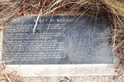
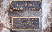
Private F.C.
Ross, memorial plaques, Mt Waverley |
Two bronze
plaques with raised bronze lettering set into a conrete
base at ground level |
Located at
the base of a Eucalyptus tree, east of Blackburn Rd,
north of the freeway – at the intersection of England Rd
with Blackburn Rd near the Monash Freeway |
60J6
|
ORIGINAL PLAQUE
F.C. ROSS
2700 E 12TH BATT
CRB PLAQUE
COUNTRY ROADS BOARD
THIS TREE WAS PLANTED TO
COMMEMORATE F.C.ROSS
KILLED IN ACTION IN
FRANCE IN 1917 THE ORIGINAL PLAQUE WAS UNEARTHED HERE
DURING ROAD CONSTRUCTION IN 1974.
|
Historical Notes, 1.7.21
A memorial to Pte. Frank Colin Ross, killed in action on
25 February 1917. The original plaque was uncovered in
1974 during road works for the Monash Freeway. In 2006
VicRoads made repairs to the original concrete setting
made by Country Roads Board and set the two plaques ona
wider concrete base. The
Australian War Memorial “First World War Nominal
Roll”, lists a private Frank Colin Ross (5761) of
the 12th Battalion who was Killed in Action on 25
February 1917. His service number is listed by
the AWM as 5761. The number 2700 refers to the tree in the
Ballarat Avenue of Honour. It is believed that the plaque found in 1974
was the original which had been subsequently replaced with others in the
Avenue in 1931. |
 |
Prows Family
& Property, Mt.Waverley – 1990. |
A bronze
plaque with raised bronze lettering set into the
footpath. |
On the
footpath outside the original house, 89 Stanley Avenue,
Mt. Waverley, west side, close to Ferntree Gully
Rd. |
70B7
|
THE PROWD FAMILY
This plaque
marks the place where William Prowd decided to settle.
William (1817
– 1901). A gentleman farmer from Armagh, Northern Ireland
and his wife Mary (nee Doolan 1818 – 1897) arrived in
Victoria in 1851. William purchased land in the Parish of
Mulgrave north of Ferntree Gully Road from the crown in
1853. His family consisted of five sons and a daughter,
the sons assisting on the farm.
William, a
devout Anglican, helped to initiate a Sunday School at
the Oakleigh Church of England and petitioned for the
establishment of the Oakleigh State School.
Charles,
(fourth son) and his wife Elizabeth (nee Christie) opened
up a gravel pit and continued to farm their portion of
the property. After the sale of several acres, they
donated land for a private road known as Stanley Avenue
to provide access to new residents. For over a century 65
acres remained in the ownership of the Prowd family.
Placed by the
City of Waverley on 25 November 1990.
Cr. T. M. Heffernan JP
Mayor
|
Historical
note, 14/2/2008:
The Prowd family (AKA. Prout) from Ireland were amongst
the first landowners in the Mulgrave-Oakleigh district.
William and Mary bought land north of Ferntree Gully Road
in 1853 and set about farming with his children. |
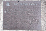 |
Riversdale
Golf Club, Centenary Year – 1992. |
A bronze
plaque with raised bronze lettering set into a small,
concrete base. |
The plaque
commemorates the planting of a Copper Beech tree in 1992.
Located just off pathway heading towards the first tee on
the east side under tree. |
61A11
|
RIVERSDALE
GOLF CLUB
PLANTED IN
THE CENTENARY
YEAR 1992
COPPER BEECH
FAGUS
SYLVATICA PURPUREA
|
Permission to
view should be gained from Riversdale Golf Club.
Note, 9/6/2008:
Riversdale Golf Club had its beginning during the early
part of October 1892 & can proudly claim to be the
second oldest Golf Club in Victoria – only Royal
Melbourne has a marginally longer history.
Originally formed as
Surrey Hills Golf Club the Club was located at Mont
Albert some 6 kilometres north of its present location.
In 1907 the club moved to Camberwell and a short time
later changed its name to Riversdale Golf Club, retaining
this name when it moved to the present location at St.
Johns Wood, Mount Waverley in May 1927.
From its early days
as a country estate owned by Sir Redmond Barry (famous as
the Judge who sentenced Ned Kelly to death) the property
has been developed into what is undoubtedly one of the
most picturesque golf courses in Victoria with numerous
varieties included in the thousands of trees which line
the Clubs fairways and providing a testing challenge for
even the straightest of hitters.
Riversdale’s first
Clubhouse building consisted of Sir Redmond Barry’s
original home together with additions carried out during
1927/1928. The larger ground floor rooms of the homestead
were left basically intact but the roof was raised to
enable addition of upstairs rooms and the existing
basement was excavated further to provide locker room
accommodation. The renovated Clubhouse was featured in
the Australian Home Beautiful magazine during a 1929
series on golf clubs of Victoria and copies of the
article are on display in the existing Clubhouse. The
building remained in this form until further alterations
were completed in 1955 with the addition of the current
Bar.
Further additions
were completed in 1988 with provision of improved
administration facilities, a new entrance to the building
and major alterations made to the Clubs liquor storage
area. Toilets were installed adjacent to the Lounge and
Dining Room together with extensive upgrading of the
Kitchen facilities which service the excellent dining
facilities available.
Although altered
three times over the years, the Clubhouse remains on its
original site and still contains considerable portions of
the original homestead purchased with the property in
1927 and thus serves as a tangible part of the continuing
history of Riversdale Golf Club.
|
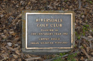 |
Rostrum Tree
Planting, Jells Park – 1984. |
A bronze
plaque with raised lettering. |
Jells Park,
to the east of the main driveway in from Waverley Rd and
about 250 metres to the north east of the main Visitors’
Centre/Cafe building. Located beneath a tree. |
72A6
|
ROSTRUM VICTORIA GOLDEN JUBILEE
This Angophora
commemorates Victorian Rostrum’s Golden Jubilee
“I
promise not to be silent when I ought to speak.”
|
Note,
21/3/2008:
Placed to celebrate the Golden Jubilee of the
organisation.
Rostrum
is an Australian organisation made up of small clubs
situated throughout the country. Members help each other
to increase their confidence and improve their speaking
skills in a warm, friendly and co-operative environment.
|
 |
Jells Park
Picnic Shelter, Rotary – 1996. |
A pressed
metal plaque with white painted lettering. |
Jells Park,
entrance road from Waverley Rd, immediately east of the
road and approximately 250 metres north of the main
Visitors’ Centre/Cafe block. |
72A6
|
This picnic shelter is a joint project of the
ROTARY CLUB OF GLEN WAVERLEY AND MELBOURNE PARKS &
WATERWAYS
Original
concept and design by MELBOURNE PARKS & WATERWAYS
Constructed
and financed by ROTARY CLUB OF GLEN WAVERLEY
Officially
opened March 1st, 1996
|
Note,
21/3/2008:
Placed to commemorate the joint project by Rotary club of
Glen Waverley and Melbourne Parks & Waterways to
erect a public picnic shelter.
Rotary Club of Glen Waverley:
Founded in 1972 through the sponsorship of the Rotary
Club of Waverley. The club began with 34 foundation
members, with Bill Pratt as the Club President. The
Village Green Hotel was the venue for the foundation
meeting and has been the venue for all meetings since,
apart from a short period of time when the hotel
underwent extensive renovations.
The club members have
funded and organised many projects, such as the transport
and restoration of a relocated old house to the Glen
Waverley Secondary Collage Camp at Nayook, built and
furnished CARA (a house for young girls), and the
construction of an Abbeyfield house, (a residence for
elderly people). The club has also built three
shelters at Jells Park and has hosted a number of
exchange students from around the world. The club
has also sponsored secondary college students to attend
the National Youth Science Forum and the Model United
Nations Assemblies and has supported many other community
activities.
|
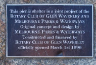 |
Scotchman’s
Creek Linear Park, Mt Waverley, section opening – 1988. |
A bronze
plaque with raised, bronze lettering set on a honeycomb
rock. |
Located on
the east side of Crosby Drive, north of Stableford
Avenue. Located at the commencement of the bike/walking
track. |
70K3
|
Scotchmans
Creek Linear Park
A Bicentennial Commemorative
Project
Development of this section
of Linear Park
Was jointly funded by the
Commonwealth,
Victorian and Local
Governments.
Project Management
Construction Agency
City of Waverley
|
AUSTRALIA’S BI-CENTENNARY, 1788-1988.
Note: 12/3/2008.
The plaque is set into a honeycomb rock and faces
south-west, close to the eastern footpath.
The Blackburn Rd to
Waverley Rd section of the Linear Park, following
Scotchmans Creek was completed as part of the 1988
Bicentennial celebrations.
|
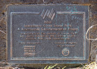 |
Scotchman’s
Creek Run, Mt. Waverley (1840) – 1985. |
A bronze
plaque with raised, bronze letters set into the footpath. |
Huntingdale
Rd, Mt. Waverley, east side, south of Waverley Rd.
Note: 13/2/2008
Located in front of Contessa Receptions.
|
70A3
|
THE SCOTCHMAN’S CREEK RUN, 1840
In January
1840, John McMillan, the Scotchman, leased 5 square miles
of country, (1,296 hectares) around the creek which
drains into that part of Gardiner’s (or Allen’s or
Kooyong Koot) Creek flowing through the north-west corner
of Waverley. Historian Susan Priestly, described The
Scotchman’s Creek Run (1840) “Begin on the creek
where it comes closest to Dandenong Rd at Oakleigh, the
line would go along Dandenong Rd to Wellington Rd
to Springvale Rd, north along Springvale Rd – to Waverley
Rd and back along Waverley Rd to the high ridge above the
creek.”
The rolling
country with “good pasture, moderately timbered with
gum and box” soon nurtured many runs such as
“Corhanwarrabul”, “Tirhatuan”,
“Bushy Park” and “Allen’s Creek”. In
1894, the banks of Scotchman’s Creek were damaged by gold
diggers and later by highway and freeway.
Placed as part
of the Victoria 150 celebrations in the City of Waverley,
by the students of Wesley College, Spring, 1985.
|
VICTORIA 150
CELEBRATIONS
Note: 6/3/2008:
The plaque contains an incorrect spelling of Priestley.
Historical note,
8/3/2008:
John McMillan leased, in January 1940, five square miles
of land around Scotchman’s Creek. This was later sold to
a Dutchman named Van Amstel.
|
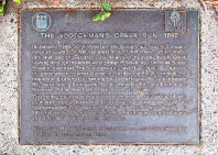 |
Sir Redmond
Barry’s Country Estate “Syndal” (1869) – 1985. |
A bronze
plaque with raised, bronze letters set into the footpath. |
High Street
Rd, north side, west of Lawrence Rd, Mt. Waverley. |
61H12 |
“SYNDAL”
Sir Redmond
Barry, KCMG, Chief Justice of Victoria named the
property, ‘Syndal’ and lived here from 1869 – 1880.
Syndal was developed as a country estate producing many
fruits, herbs, flowers, vegetables and grapes, eventually
giving its name to the area.
Placed as part
of Victoria 150 celebrations in the City of Waverley, by
the students of Syndal High School, Autumn, 1985.
|
VICTORIA 150
CELEBRATIONS.Historical note
13/2/2008:
From July 1869, Sir Redmond Barry planted fruit trees and
vegetables on this estate thus becoming one of the
pioneer orchardists in the area. The name
“Syndal”, meaning sunny dale, was another of
the legacies he left to Waverley.
It is doubtful if it could be said the
Barry “lived here”. It is more likely
that he stayed on the property for some period of time on
numerous occasions.
Note: Located in front of “The
Oaks” residential development (formerly the Colman
property), 547 High Street Rd, 100 metres west of
Lawrence Rd.
Historical Note,
9/6/2008:
Redmond Barry (1813–1880)
Sir Redmond Barry is
perhaps the best known of Melbourne’s early legal
practitioners. Although he neither studied nor taught at
the University of Melbourne, he was a central figure in
the University’s early history.
Barry was born in
Ireland in 1813. He graduated from Trinity College,
Dublin, and was admitted to the Irish Bar in 1838.
Arriving in Melbourne
in 1839, Barry was soon an active member of
Melbourne’s legal community. He was appointed
Solicitor General of the newly founded colony of Victoria
in 1851 and Judge of the Supreme Court of Victoria in
1852. He was the judge at the trial of Ned Kelly in 1880.
Barry also had a key
role in the creation of some of Melbourne’s oldest
cultural institutions, including the State Library of
Victoria, the National Gallery of Victoria and the
University of Melbourne. As the University’s founding
Chancellor, he took the leading role in the establishment
of its first law course in 1857.
Barry died in 1880
and is buried near the University, in the Melbourne
General Cemetery.
|
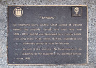 |
St Leonard’s
Catholic Church, Glen Waverley 1906 – 1985. |
A bronze
plaque with raised, bronze letters set into the footpath. |
Springvale
Rd, Glen Waverley, west side, south of Waverley Rd.
South of the main entrance to Central Reserve. |
71C5
|
ST. LEONARD’S CATHOLIC CHURCH, 1913.
This plaque
commemorates the site of the first St. Leonard’s Catholic
Church in Glen Waverley, 1913.
Placed as part
of the Victoria 150 celebrations in the City of Waverley
by the students of St. Leonard’s Catholic Primary School,
Autumn, 1985.
|
VICTORIA 150 CELEBRATIONS
Historical note,
10/2/2008:
St. Leonards was opened as a country outpost of the
Oakleigh parish. Built in 1913, the building was
later moved in 1956, north, along Springvale Rd to the
site of the new St Leonard’s Centre.
|
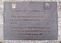 |
St. Stephens
Church & Common School, Mt. Waverley. (1865) – 1985. |
A bronze
plaque with raised, bronze letters set into the footpath. |
High Street
Rd, north side, west of Alice St, Mt. Waverley. |
61D11
|
ST. STEPHEN’S CHURCH, MT. WAVERLEY
Designed by
Nathaniel Billing and built by William Weir with bricks
baked from local clay by William Stevenson, it was
licensed by Bishop Perry 9/7/1865, and opened for divine
service 23/7/1865, the first service being conducted by
Rev. T.C. Cole. A Common School was established, 1866-7.
Placed as part
of the Victoria 150 celebrations in the City of Waverley,
by the students of Ashwood High School, Autumn, 1985.
|
VICTORIA 150 CELEBRATIONS
Historical note,
13/2/2008:
This was the first church built in Waverley and is now
the oldest standing church building in Waverley. It is
built from hand-made bricks and contains a memorial
window (1914-1918). This now known as St. Stephen &
St Mary following the incorporation of the St Mary’s
Parish.
|
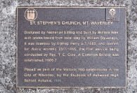 |
Stott
familyproperty, Wheelers Ridge,Wheelers Hill – 1973. |
A bronze
plaque with raised, bronze lettering fixed to a bluestone
retaining wall adjacent to the footpath. |
On private
property, 10 Alex Avenue, Wheelers Hill, west side.
Viewed from the footpath. |
71J8
|
WHEELERS RIDGE
This plaque
was placed here on
2nd October,
1973
by
John Aubrey
Stott
To honour the
pioneering owners
of this
property
1854 –
1973
|
Historical
Note, 17/2/2008:
Placed to mark the ownership of the surrounding land by
Sidney T. Stott.
Stott was the owner of Stott’s Business School,
Melbourne.
This large property
was bought by Sidney T. Stott from John Wheeler in 1854 –
in total, 246 acres and was named
“Elinora”. In 1916, Sidney Stott planted
100 acres with 10,000 fruit trees apples with 7000 being
various varieties of apples and 2000 being pear trees.
After returning from WWI, his son, Aubrey improved on the
orchards using early mechanised means, such as tractors,
a grader and high powered pumps. He also built a large
cool store on the property and employed modern methods to
obtain heavy cropping.
|
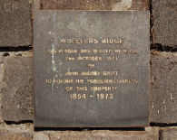 |
Syndal
Primary School, Opening of Art & Craft Centre – 1970. |
A bronze
plaque with recessed white letters. |
Now held by
the Waverley Historical Society and housed in the
Society’s rooms, Miller Crescent, Mt Waverley. |
61E1
|
SYNDAL PRIMARY SCHOOL
I.D. HISLOCK
AND A.C. RAPHAEL
ART AND CRAFT
CENTRE
THIS CENTRE
WAS ERECTED BY THE PARENTS AND FRIENDS OF THE
SCHOOL IN CONJUNCTION WITH THE EDUCATION DEPARTMENT, AND
WAS OFFICIALLY OPENED ON 28TH DAY OF JULY, 1970, BY MR.
F.H. BROOKS, M. SC., DIP. ED., F.R.A.C.I., F.A.C.E.,
DIRECTOR-GENERAL OF EDUCATION.
|
Note,
9/4/2008:
Placed originally when the school’s Art and Craft Centre
was officially opened in 1970.
This plaque was removed from the school when it
was closed and forwarded to Waverley Historical Society
for storage and safekeeping.
|
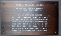 |
Syndal
Primary School, Library Opening – 1965. |
A bronze
coated steel plaque with recessed white lettering. |
Now held by
the Waverley Historical Society and housed in the
Society’s rooms, Miller Crescent, Mt Waverley. |
61E1
|
THIS LIBRARY
WAS ERECTED FOR THE STUDENTS OF THE SYNDAL STATE SCHOOL
BY THE PARENTS AND FRIENDS OF THE SCHOOL IN CONJUNCTION
WITH THE EDUCATION DEPARTMENT, AND WAS OFFICIALLY OPENED
BY THE ASSISTANT MINISTER OF EDUCATION THE HONOURABLE
J.F. ROSSITER, M.P., ON THE 28TH DAY OF MAY, 1965. |
Note,
9/4/2008:
Located originally inside the school library building to
mark the opening of the library in 1965.
This sign was removed
from its original location and placed in the care of
Waverley Historical Society.
|
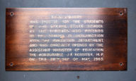 |
Tait’s Post
Office & Store, Mt.Waverley (1905) – 1985. |
A bronze
plaque with raised, bronze lettering set into the
footpath. |
Stephensons
Road, east side, Mt Waverley Shopping centre.
Note, 14/2/2008: Located
on the traffic island between the south bound lane of
Stephensons Rd and the carpark. Midway between Waimarie
Drive and The Highway.
This current location
is approximately 100 metres south of the actual site of
the store which is where the Christian Science Reading
Room now is.
|
70E1
|
TAIT’S STORE
The site of
the first Post Office Store in Mt. Waverley, operated
from 1906 to 1944 by Mrs. Tait and her daughters, Blair
and Lily, who lived on the adjoining property,
“Waimarie”.
Placed as part
of the Victoria 150 celebrations in the City of Waverley
by the students of Huntingtower School, Autumn, 1985.
|
VICTORIA 150 CELEBRATIONS
Historical note,
14/2/2008:
Because the district was not allowed to have a full post
office, in 1905, Mrs. Tait who lived at
“Waimarie” in Stephensons Road was offered a
stamp-selling licence and on a ‘trial basis’ a loose mail
bag was taken from Mrs. Tait’s on Tuesdays.
From her little
store, she began stocking sweets, exercise books and
pencils. Blair and Lily Tait kept the store running until
1944 and customers summoned the women from the house by
ringing a small bell.
|
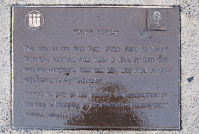 |
Tally Ho
Hotel & Race Track, Burwood East, (1877) – 1985. |
A bronze
plaque with raised, bronze lettering set into the
footpath. |
Highbury
Road, south-west corner of Blackburn Road, Burwood East. |
61K9 |
THE TALLY HO INN AND RACE TRACK
Before 1875,
this district was known as Harkaway or Tally Ho. When
licensee Fred Jones re-named his Inn the “Tally
Ho”, the settlers adopted that name in which one can
still hear the echoes of their horses & hounds, &
of the hunts or the paper chases when the foxes were not
available. The race track, opened in 1893 and adjoining
the Inn along Highbury Road, boasted a carnival meeting
featuring foot and horse racing and buckjumping for some
2000 spectators on Easter Monday, 1899.
Placed as part
of the Victoria 150 celebrations in the City of Waverley
by the Council, Spring, 1985.
|
VICTORIA 150 CELEBRATIONS
Historical note,
11/12/2008:
From c.1864 there had been a store on the North Boundary
(Highbury) Road – Blackburn Rd corner diagonally opposite
the new school on the north east corner. In 1871,
Frederick Jones got a licence to open a hotel adjoining
the store.
After 1885, for a
time, the Tally Ho Hotel was de-licensed but within a few
years, Alexander Hunter, a builder was able to buy it. In
1890, it re-opened again.
Hunter also began the
Tally Ho Race track in 1898. On Easter Monday,
1899, 2000 people turned up for the carnival.
|
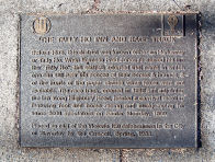 |
Thomas Evans
Doughton, Riversdale Golf Club. |
A bronze
wall-mounted plaque with raised bronze lettering. |
Located on
wall outside Pro-Shop under the clock. |
61A11 |
A TRIBUTE
TO THE MEMORY
OF
THOMAS EVANS
DOUGHTON
WHO SERVED THE
CLUB SO WELL
CAPTAIN 1929
PRESIDENT 1935
– 1947
|
Note,
20/2/2008:
Permission to view should be gained from Riversdale Golf
Club.
Placed to
honour Thomas Doughton (b. 1888) who was Captain and
President of Riversdale Golf Club between 1929 and 1947.
|
 |
Thomas Napier
& Madeline Scott, Glen Waverley (1839) – 1985. |
A bronze
plaque with raised, bronze letters. |
High Street
Road, Glen Waverley, south side, west of Dandenong Creek,
near the entrance to Napier Park.
Note: 10/2/2008.
The plaque is located
20 metres to the east of the main entrance to Napier Park
within an area of native plantings.
|
71J11 |
THOMAS NAPIER AND MADELINE SCOTT:
FIRST EUROPEAN
SETTLERS.
Thomas Napier,
a skilled builder and entrepreneur came from Van Diemen’s
Land to the early settlement on the Yarra.
In October
1839, he began squatting here on Dandenong Creek with
cattle bought from overlanders, Watson and McLean. He
built his hut somewhere in Jells Park. In 1841, he sold
the run to Alexander and Madeline Scott. Alexander died
soon after. Madeline, with the courage and
resourcefulness typical of pioneer women, caused this run
which she named “Bushy Park” to prosper,
supplying meat and dairy products to the shopkeepers of
Collingwood. In 1844 she sold “Bushy Park” to
the Drew brothers, taking up a second leasehold on the
other side of this creek.
Placed as part
of the Victoria 150 celebrations in the City of Waverley,
by the Council, Spring, 1985
|
VICTORIA 150 CELEBRATIONS
Historical note,
9/6/2008:
Thomas Napier was born in 1802 in Scotland. He was the
son of James Napier, a weaver from Montrose and Margaret
Suttor. He had a number of jobs in Scotland, working as a
clerk and training as a carpenter. He also received a
couple of years of training as an artist.
In 1832 he left
Britain with his business partner John Brown (who was
later to build “Como” house in South Yarra).
They arrived in Hobart Town in the same year and
commenced work on the construction of several buildings.
In 1836 he married
Jessie Paterson, who had arrived in Hobart Town earlier
that year also from Scotland.
Mr. Napier was
dissatisfied with conditions in Hobart and Van Diemen’s
land and in 1837 sailed for the settlement at Melbourne.
This was only two years after the first permanent
settlement on the Yarra River by parties of settlers
organised by John Batman and John Pascoe Fawkner.
When Napier arrived
in Melbourne no land had yet been made available for
purchase and most of the structures in the area were
still temporary, constructed using “wattle and
daub”. In the first land sale in Melbourne he
purchased a half acre allotment in Collins Street for 20
pounds. In a subsequent sale a few months later he
purchased another quarter acre allotment (also for 20
pounds). He built a “wattle and daub” cottage
on one of the sites and continued with his building
business.
At around the same
time he also settled on land in the vicinity of Jells
Park on the Dandenong creek (as a “bona fide
squatter”). In April of 1842 he had the misadventure
of being stuck-up by two bushrangers on Dandenong Road,
which was quite a novelty at that time in that location.
One of the bushrangers was later shot and the other
hanged.
In 1839, he
“squatted” on this land but was unimpressed
with the lack of pasture for his animals and sold to
Alexander Scott.
Scott soon died and
left his resilient wife, Madeline to look after their
children and run the property which they had named
“Bushy Park”. After taking on partners, Mrs.
Scott moved on, leaving the surviving partners, the Drew
brothers to run the property.
He was not
satisfied with the nature of the pasture at Dandenong and
in 1845 purchased 100 acres of land on Moonee Ponds Creek
from E. J. Brewster, in the area now known as Strathmore
and built the house “Rosebank”. Members of the
Napier family lived on this land into the 1920’s (apart
from some lengthy overseas trips to Scotland by both
Thomas and Theodore Napier).
In 1859 Thomas Napier
left Melbourne for England and Scotland. He returned in
1860 however his eldest son Theodore remained in Scotland
to complete his education.
Thomas Napier was
made a Justice of the Peace in 1860. He also had the
honour of laying the Foundation Stone of the Pascoe Vale
National School (c. 1850) which was located adjacent to
Moonee Ponds Creek where Five Mile Creek enters. (The
Pascoe Vale National School was sold in the early 1860’s
and the students relocated to the new Essendon Common
School in Raleigh Street, Essendon, the current site of
Essendon Primary School.)
Thomas died in 1881
leaving his wife, Jessie, his son Theodore, and daughter,
Eleanor Barber. Thomas Napier can truly be described as
an early pioneer in the Port Phillip District and
Strathmore.
On the death of
Thomas Napier his land was divided between Theodore and
his wife, Jessie.
|
 |
Shire of
Mulgrave, Toll Gates, Ashwood (1868) – 1985. |
A bronze
plaque with raised, bronze letters set into the footpath. |
High Street
Road, Ashwood, south side, east of Warrigal Road.Note: 13/2/2008. Located several metres east of
the High Street Road entrance to Safeway. |
60H10 |
THE TOLL GATES
Toll gates
with the toll-keepers’ houses were erected on Dandenong
Road in 1864, on Breakneck Road (later Waverley Road) in
1866 and at this site in 1868. The toll was expensive:
variously 6 pence or 12 pence per passage. Traffic was
heavy, one Dandenong Road collected £1235 ($2470), in
1870. Tolls, like any tax, were never popular, were
regularly avoided or grudgingly surrendered. Toll
keepers, too, were the frequent butt of practical jokes,
but the extent of the road use demonstrates their
importance to the community.
Placed as part
of Victoria 150 celebrations in the City of Waverley, by
Council, Spring, 1985.
|
VICTORIA 150 CELEBRATIONS
Historical note,
9/6/2008:
In January 1857, the Oakleigh and Mulgrave District Roads
Board was formed to raise money and turn theoretical
roads into practical routes for coaches and carts and
drays and bullock teams and horses and pedestrians. In
fact no one could be persuaded to stand for election to
the Roads Board until 1860. After that some progress was
made in forming roads. Mainly the Roads Board relied on
Government grants and income from the toll gates set up
along the main roads.
The local Road Board
was given a share of tolls from the district and much of
this was spent in collecting and burning dead trees and
logs which cluttered the tracks. Travellers tried to
evade the toll gates by finding tracks around them. In
1874 an Act of Parliament decreed the gradual phasing out
of all toll gates and those in High Street Road and
Waverley Road were dismantled in 1876.
|
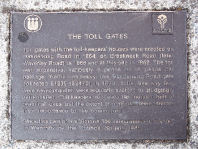 |
Town Common,
High Street Rd, Glen Waverley (1861-1906) – 1985. |
A bronze
plaque with raised, bronze letters set into the footpath. |
High Street
Rd, Mt. Waverley, south side, west of Rose Street.
Note: 11/2/2008.
It is located adjacent to the eastern boundary fence of
Wesley College, 70 m west of Rose St.
|
61A12 |
THE TOWN COMMON : 1861 – 1906
These 65
hectares (160 acres) immediately south and west to
Blackburn Road, were proclaimed common in 1861 for the
townspeople’s working horses, bullocks and household
cows. The flat ground, a favourite picnic and sporting
spot for the Muir, Seller, Pepperell and Mullens
families, became in 1906 a specialist apple orchard and
market garden until acquired by Wesley College, 1955 to
1959.
Placed as part
of the Victoria 150 celebrations in the City of Waverley,
by the students of Wesley College, Autumn, 1985.
|
VICTORIA 150 CELEBRATIONS
Historical note,
11/2/2008:
A town common was established in this area on the south
side of High Street Road and extending west to Blackburn
Road. It was one of several in the Shire of Mulgrave.
Here, local farmers and growers were able to rest their
horses and other farm animals.
|
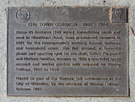 |
Town Common,
Waverley Rd, Mt Waverley (1861) – 1985. |
A bronze
plaque with raised, gold letters set into the footpath. |
Forster Road,
west side, cnr Waverley Rd, Mt. Waverley. |
61F4 |
THE TOWN COMMON, 1861
Early in 1861,
the town common was proclaimed on three unsold blocks:
one in High Street Road on Gardiner’s Creek between
Huntingdale and Warrigal Roads, a second on High Street
Road between Springvale and Blackburn Roads where Wesley
College and the Syndal shops now stand, and this block in
Waverley Road backing down to Scotchman’s Creek between
Forster and Stephenson’s Roads. It provided for the
townspeople’s working horses, bullocks and household
cows.
Placed as part
of the Victoria 150 celebrations in the City of Waverley,
by the Council, Spring, 1985.
|
VICTORIA 150 CELEBRATIONS
Historical note,
13/2/2008:
In addition to their own small farms the people looked to
common land to provide extra grazing for their working
animals. However, in the 1870s these blocks were sold and
John Forster obtained the title to the common land at the
corner Waverley and Forster Roads.
|
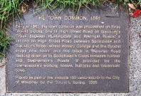 |
Township of
“Waverley”, Mt Waverley (1854) -1985. |
A bronze
plaque with raised, bronze letters set into the garden
bed. |
Reserve
– south East corner of Stephensons and High Street
Rds, Mt. Waverley – south end adjacent to nearby housing
units. |
61E11 |
THE TOWNSHIP “WAVERLEY”
In 1864, Dr.
Silverman, a Russian-born doctor purchased for £760, a
quarter-mile block extending south and east from this
intersection. This land he subdivided and named the
“Township of Waverley”, thus perpetuating his
admiration for the works of the novelist, Sir Walter
Scott.
Placed as part
of the Victoria 150 celebrations in the City of Waverley,
by the students of Mt. Waverley High School, Autumn,
1985.
|
VICTORIA 150 CELEBRATIONS
See also marker
31 south east corner of Charles and Portsmouth Sts,
Mt Waverley.
Note:
13/2/2008.
The small, square stick-on logo for Victoria 150 has been
lost from the top right-hand corner of the plaque.
Historical note,
13/2/2008:
Dr Silverman, a Russian by birth, bought land at this
corner for 760 pound. He had arrived in 1852 and later
surveyed and subdivided his property, calling it
“Waverley” and he hoped to encourage a township
to grow here. His grand vision didn’t come to pass until
much later when suburban development caught up. However,
the name “Waverley” survived in peoples’ minds.
|
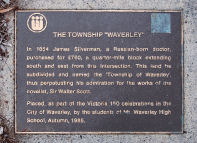 |
Footbridge,
Valley Reserve, Mt. Waverley – 1977. |
A triangular
shaped bronze plaque with raised, bronze letters. |
Entrance from
the corner of Waimarie Drive and Wills Ave, Mt.
Waverley. Note: 29/2/2008.
The plaque is located across the footbridge,
approximately 100 m. from the entrance to the park. To
the left of the main access road in the park – eastern
end of the bridge. |
70G2 |
THIS BRIDGE
WAS CONSTRUCTED BY
APEX CLUB OF WAVERLEY
AND
OPENED BY COUNCILLOR L.
M. RYAN MAYOR,
CITY OF WAVERLEY ON 11
DECEMBER, 1977
|
Note,
29/2/2008:
Commemorating
the opening of the footbridge over the creek within
Valley Reserve.
|
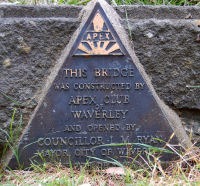 |
VicRoads –
World Environment Day, Mt Waverley – 1990. |
A gold
burnished plaque with recessed black lettering mounted on
a honeycomb rock. |
On the
embankment on the Ferntree Gully Rd on-ramp to the Monash
Freeway. Entrance to the on-ramp is from the south side
of Ferntree Gully Rd, west of Springvale Rd. |
71A8 |
VIC ROADS
THIS
PLANTATION WAS
ESTABLISHED TO
COMMEMORATE
WORLD
ENVIRONMENT DAY
5 JUNE 1990
|
Note,
21/3/2008:
Erected to commemorate World Environment Day and a stand
of trees planted.
Access is only possible by stopping on the
on-ramp to the freeway. There appears to be no access
from the southern side of the embankment.
|
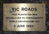 |
Visitors
Centre Opening, Jells Park, Wheelers Hill, 1978. |
Three bronze
plaques with raised bronze lettering. |
The three
plaques are mounted on the brick wall on the western side
(main entrance) to the building, Jells Park, entrance
from Waverley Rd. |
71K6 |
PLAQUE 1:
THIS PLAQUE COMMEMORATES THE OFFICIAL OPENING OF
VISITORS CENTRE DANDENONG VALLEY METROPOLITAN PARK
BY THE
HONOURABLE R. J. HAMER ED, MP
ON MAY 23, 1978
MELBOURNE AND
METROPOLITAN BOARD OF WORKS
PLAQUE
2:
CHAIRMAN A.H. CROXFORD LLB
DEPUTY CHAIRMAN E.W. BEST CMG
COMMISSIONERS:
J.E. BOWN JP
G.R. BRICKER JP
J.K. BYRON JP
R.G. BYSOUTH JP
K.F. CHAMBERLIN JP
R.B. COMBEN JP
F.G. COX JP
P.F. DAVIES JP
D.W. BUMBRELL JP
B.S ELMS JP
F.J. FINN
F.G. FORD JP
W.J. FOSTER JP
A.M. GIBSON
A.G.E GILLON OBE, JP
D.K. GRANT JP
J.T. HARDING
M.G. HARDY
K.M.S. HOLLAND
J.B.JACKSON JP
D.C. JONES
R.F. JULIER
G.G. KERMONDE
P.T. LALOR
K.C. LEAR JP
A.A. MCCUTHEON
P.J. MCDOUGALL
R.W. MACEY
J.M. MCRAE
F.J. MADDERN
E.J. MARRIOTT
R.K MARSHALL
R.V. MEAGHER
J.W. MERCUS JP
V.R. MICHAEL JP
K.E. MILLER JP
A.E. MISSEN
K.G. MITCHELL
D.E. MUIR JP
K.V. NICHOLLS JP
W.N. OATES
G.D. O’CONNELL
A.R. PATTERSON MBE, JP
L.F. PAYNE OBE, JP
D. QUADARA
K.A.F READWIN
J.D. RYAN, JP
N.W. SMITH JP
W.H. TEW MBE, JP
W.R. WALTERS MBE, JP
I.G.N. WARNER
B.F WATERS
R.D. WHITE, JP
B.T. ZOUCH, JP
MAY 23, 1978
PLAQUE
3:
INAUGURAL DANDENONG VALLEY METROPOLITAN PARK
ADVISORY COMMITTEE
MEMBER
REPRESENTING
COMMISSIONER
L.F. PAYNE (CHAIRMAN) MMBW PLANNING COMMITTEE
COMMISSIONER
P.F. DAVIES MMBW PLANNING COMMITTEE
COMMISSIONER W.H. TEW MMBW PLANNING COMMITTEE
MR. R.D. EGAN-LEE CITY OF KNOX
MR. J. HALFORD CITY OF WAVERLEY
MR. W. STEWART CITY OF NUNAWADING
MR. D.P. GAWLER CITY OF NUNAWADING
MR. A.C. ROBERTSON CITY OF RINGWOOD
MR. T.S.L. STITT CONSERVATION COUNCIL OF VICTORIA
MR. D. POWNEY DEPARTMENT OF YOUTH, SPORT AND RECREATION
MR. S.W. CALDER FORESTS COMMISSION OF VICTORIA
MR. A.M. COONEY MINES DEPARTMENT
MR. D. THOMPSON DANDENONG VALLEY AUTHORITY
MR. B. PEYTON COUNTRY ROADS BOARD VICTORIA
MR. H. G. THORPE STATE ELECTRICITY COMMISSION OF
VICTORIA
MR. G.P. HAYES MEMBER OF PARLIAMENT
MR. D.W. SIMPSION MMBW
MR. K. RASMUSSEN MMBW
MR. T. ARTHUR MMBW
|
Placed to
commemorate the building and opening of the Visitors
Centre in 1978.
Historical
note, 9/6/2008:
Jells Park is at the hub of a network of parklands linked
by the Dandenong Creek. Nestled in the heart of suburbia
the park is abundant with native plants and wildlife and
is a diverse recreation destination for the whole family
– you can experience it all in Melbourne’s backyard.
With over nine km of
paths and trails, hectares of wide open spaces and picnic
areas for everyone to enjoy.
Named after one of
the first pioneer settlers in the area, Joseph Jell, the
park has had an interesting history, being used for
grazing, a piggery and even a storage area for the
American Army during World War 2. Prior to European
settlement, Aborigines from the Woiworung and Bunurong
tribes lived on the land for over 30,000 years.
Jells Park was
officially opened in April 1976 and is now one of the
most popular parks in Melbourne catering for over 700,000
visitors
|
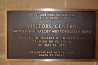 |
Waverley
North Primary School – Opening of the Library, 1969. |
A bronze
plated steel plaque with recessed white letters. |
Now held by
the Waverley Historical Society and housed in the rooms
first floor Mt Waverley Library Miller Cres, Mt Waverley. |
61E1 |
WAVERLEY NORTH STATE SCHOOL
THIS LIBRARY
WAS ERECTED BY THE PARENTS AND FRIENDS OF THE SCHOOL IN
CONJUNCTION WITH THE EDUCATION DEPARTMENT, AND WAS
OFFICIALLY OPENED ON 26TH SEPTEMBER 1969
BY THE HON.
L.H.S. THOMPSON. M.L.C., MINISTER OF EDUCATION.
|
Note,
9/4/2008:
Originally placed on the wall of the school’s library
when it was opened in 1969. The plaque was removed when
the school was closed and the library was demolished. It
was subsequently placed in the care of Waverley
Historical Society. |
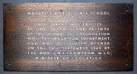 |
Wesleyan
Church, Black flat & School, Glen Waverley (1868) –
1985. |
A bronze
plaque with raised, bronze letters set into the footpath. |
Waverley
Road, Glen Waverley, south side, west of Springvale Road,
near Bowling Club. |
71B4 |
THE WESLEYAN CHURCH, BLACK FLAT
Site of the
original Black Flat Wesleyan (later Glen Waverley
Methodist) Church 1867-92 (used also as original Black
Flat School) on land donated by James Colley, Class
Leader.
Placed as part
of Victoria 150 celebrations in the City of Waverley, by
the students of Brentwood High School, Autumn, 1985
|
VICTORIA 150 CELEBRATIONS
Historical note,
17/11/2008:
James Colley was one of a number of settlers who bought
land at Black Flat in the 1050s. By 1864 he was leader of
a group of 12 Wesleyans nearby. In 1866, he first
suggested that a meeting hall be built but it took over a
year to gain permission from the Wesleyan circuit and
then only if it cost less than 10 pounds to build! A
small chapel with a shingle roof was in use as a school
which became the focus of the district. It became a State
School in 1872, until the new brick school was built and
ready for use in 1880.
The small
weatherboard chapel was the focus of community life and
worship for many years until a new church was built in
Springvale Road, at the corner of Kingsway in 1962.
|
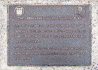 |
Damper Creek
– 40th Anniversary of FODC. Mt Waverley – 2008 |
A bronze
metal plaque with raised bronze lettering recessed into a
large honeycomb rock, supported on a log base. |
Damper Creek
Reserve, at the northern end of Alice St, 50 metres to
the west of the road, close to the bridge over the creek. |
61E10
|
40 year Commemoration
On 26th
September, 1988, a group of
concerned
Waverley residents met and formed
“The
Damper Creek Conservation
and
Development Group”
their efforts
helped preserve this bushland reserve
for future
generations.
Erected in
November, 2008 in recognition of their efforts
by the Friends
of Damper Creek Reserve Inc.
|
Note,
8/12/2008:
The official dedication ceremony held at the site was on
Sunday 30 Nov, 2008
Note re: F.O.D.C. Inc, 8/12/2008:
Damper Creek was probably a valuable food source for the
traditional inhabitants of the area, the Wurundjeri.
Later it was a rest place and water source for stockman.
Damper Creek Reserve
played a small part in the building of St Stephen’s
Anglican Church in High Street Rd, Mt Waverley. The plans
for the church were drawn up in 1864 and donations were
requested to pay for the building. The congregation
contacted a William Stevenson (Stephensons Road, a
variation, was named after him), to bake the bricks and
he obtained his clay from the crossfire of gullies around
Damper Creek. The bricks were fired in a kiln built near
the creek and the church members carried them up the
hill.
Orchards, market
gardens and farms soon surrounded the creek until after
World War 2 when the city began to spread eastward.
Damper Creek and the
surrounding bushland was saved by local residents from
subdivision and road construction in 1969. Several local
Councillors were elected on the platform of preserving
the creek for public open space.
Urban development
surrounded the Damper Creek “drain” and the
area was infested with blackberries, ivy and other
noxious weeds. Willow trees elevated the creek bed and
the banks were eroding with the increasing volume of
stormwater. The area was used as a dump for local
resident’s garden refuse and rubbish.
In the early 1990’s
circuit fitness equipment was put into the reserve but
the area was often too boggy and not an attractive or
safe place to run.
Bushland Restoration
Project:
The Friends of Damper Creek Reserve was formed in April
1993. The Friends worked in conjunction with the then
City of Waverley (now Monash Council) to begin a staged
restoration of the creek.
The Council began the
major engineering component to stabilise and reconstruct
the creek bed and banks, while the Friends successfully
applied to Melbourne Parks and Waterways (now Parks
Victoria) for funding for plants. As well as planting and
the general maintenance weeding the Friends have
constructed the middle bridge known as “Palma’s
Plummet” and the boardwalk over the Bengal Crescent
Tributary, put in the two noticeboards, erosion control
sleepers, bench seats, fencing and the aquatic ponds in
the compound.
The basalt rockwork
in Damper Creek is not indigenous to the area but was
chosen to stabilise the creek and as an attractive
landscaping feature. Claystone is the indigenous rock,
hence the history of brick making in the area.
The restoration work
has occurred from Stephensons Rd to the junction with
Damper Creek East near Alvie Hall. The project is now up
to Stage 8 which terminates at the Riversdale Golf
Course. In the future, restoration works may also occur
along the remainder of Damper Creek East behind the Bowls
Club and in Bellbird Corner (corner High Street Rd and
Stephensons Rd, Mt Waverley).
|
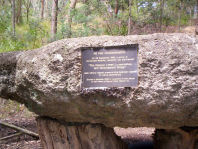 |
Gen Sir John
Monash – Bust & Plaque, Civic Centre – 1996. |
A bronze bust
and small accompanying brass plaque. |
Inside the
Foyer/Atrium of Monash Civic Centre, to the right of and
in front of the Reception Desk, against a concrete pillar
and facing the front doors. Sits on a marble table. |
71C3
|
Sir John Monash
Cast from the
original mould commissioned by the State Electricity
Commission and presented to the City of Waverley by SEC
Victoria in August 1996
|
To honour
General Sir John Monash.
Historical Note, 19/12/2008:
General Sir John Monash
The City of Monash is
named after a man regarded as one of Australia’s greatest
heroes. General Sir John Monash was a civil engineer and
volunteer soldier who rose to the highest rank in the
Australian Army by the end of World War 1.
His life and career
represent the opportunity that Australia provides for
migrants and their children to excel and contribute. He
is a model of leadership, community service, and
achievement for everybody living and working in the City
of Monash today.
The Young Man
John Monash was born
in West Melbourne in 1865 to immigrant Prussian parents,
when the Victorian Colony was barely 30 years old and the
population was just 40,000.
Monash’s was one of
the first Jewish families who arrived in Australia
seeking refuge from terror, discrimination and poverty in
Europe. In Melbourne, Jews had no work prohibitions. They
entered Parliament in significant numbers, and they had
educational opportunities and social freedom.
John Monash’s story
represents the extraordinary fortune of Australian Jewry.
Monash’s father took
the family to Jerilderie, N.S.W in 1875 to open a general
store. This is possibly where the young boy began his
life long appreciation for the Australian landscape and
for the ‘down to earth spirit’ of the locals. Contrary to
a story that he neither confirmed nor denied, Monash was
not in Jerilderie in February 1878 when the Kelly gang
came and terrorised the community and raided the bank
vault. Monash may have held the Bushranger’s horse on a
previous occasion, but by 1878 he had returned to
Melbourne with his mother and sisters to go to school.
The suggestion that two of Australia’s most famous
personalities met is an intriguing historical
possibility.
Monash was scholarly
and particularly talented at mathematics. He matriculated
at 14 and two years later he was equal Dux of Scotch
College. At the University of Melbourne he studied Law,
Engineering and Arts and became involved in broader
cultural activities, such as debating, politics, theatre
and journalism.
He co-founded the
Melbourne University Union. Monash also painted and spoke
French and German. He enjoyed chess, carpentry and
bushwalking and was an accomplished pianist.
When his mother was
dying he discontinued his studies to support his family
and worked on the construction of Princes Bridge over the
Yarra River. He eventually completed his university
studies and in 1888 he assumed responsibility for
construction of the Outer Circle railway, which
terminated at Oakleigh. He also purchased property in the
district beside the railway line.
In 1891 he married
Hannah Victoria Moss, a charismatic woman with whom he
had a turbulent relationship. They had one daughter,
Bertha, two years later.
The Engineer
In 1891 Monash was
employed by the Melbourne Harbour Trust and was
retrenched during the 1894 depression. He then developed
an enterprise with J.T. Noble Anderson specialising in
civil, mining and mechanical engineering and patents. In
1905 Monash and associates formed Reinforced Concrete and
Monier Pipe Construction Co Ltd.
This company
developed an expertise in reinforced concrete
construction, yet another innovation that he embraced.
Monash first faced failure, and then success, as a bridge
builder, and as the director of a major concrete
construction company.
The Soldier
Monash’s time in the military began while at university,
when he joined the 4th Battalion, Victorian Rifles. He
was a volunteer, not a professional soldier. He rose
through the ranks of the Militia, the reserve army.
At the outbreak of
World War 1 he became the Chief Censor before taking
command of the 4th Infantry Brigade. His career included
command in Egypt and the landing at Gallipoli.
In France his unit
played a significant role in breaking through enemy lines
in 1918 at Amiens, and was decisive in the victories at
the battles of Villiers-Bretonneux and Hamel which
involved the collaboration of infantry, artillery, tanks
and aircraft. Monash was credited with the success of the
August 8 offensive on the Western Front, regarded as the
crucial battle of World War 1. In a rare gesture by King
George V he was knighted in the field in 1918.
As a military
strategist General Monash was way ahead of his
time.
His approach was
innovative and modern, informed by his civilian
experience and training. His guiding principle was to
avoid needless loss of life, and his motto was to
“feed the troops on victory”. He followed it
literally arranging for hot meals to be delivered to his
men during battle.
Monash remained in
Europe at the end of the war and, as Director General of
Repatriation and Demobilisation, efficiently managed the
repatriation of 160,000 Australian soldiers. He organised
professional and trade skills training for the
repatriated soldiers.
By the time he
returned home to a tumultuous welcome at the end of 1919,
he was respected by senior Allied military men and
politicians, and was feted by the public. He attracted
criticism from traditionally minded officers, but won the
approval of his men and commanders who worked closely
with him. He had distinguished himself as a fine
administrator with a genius for strategy.
The Statesman
After World War 1, Monash returned to his engineering
business.
He became restless
and sought a public role, eventually becoming Chairman of
the State Electricity Commission as it began to mine coal
and generate electricity from Victorian sources.
In the 1920s he was
Australia’s most revered public figure. He enjoyed the
status and responsibility his career brought him. He knew
his was an unusual position for a Jew. General Monash led
many ANZAC parades and was the driving force behind the
building of the Shrine of Remembrance in Melbourne.
He lectured at the
University of Melbourne and was its Vice-Chancellor for
two years from 1923. Monash became the President of the
Australian Association for the Advancement of Science. He
was also President of the Victorian Institute of
Engineers and active in the Boy Scout movement.
Family was important
to him, and in retirement he spent time with the younger
generations at the family home, Iona. He died on 8
October 1931, at the age of 66, and an estimated 250,000
mourners attended the state funeral to pay their
respects.
|
 |
Novotel, Glen
Waverley, Glen Waverley – 1998. |
A bronze
plaque with raised bronze lettering. |
Located to
the right of the entrance door, hotel entrance,
Springvale Road, Glen Waverley, facing east. |
71C3
|
Novotel
Glen Waverley
Officially
opened by
THE HON.
LOUISE ASHER, M.P.
MINISTER FOR
SMALL BUSINESS AND TOURISM
ON
Wednesday 27th
July, 1998
ACCOR
|
Placed to
commemorate the opening of the Novotel in Glen Waverley.
Note, 19/12/2008:
Novotel Melbourne Glen Waverley is owned by AAPC
Properties Pty Limited which is a wholly owned subsidiary
of AAPC Limited. AAPC Limited is ultimately owned by
Accor SA, a company listed on the French stock exchange,
a worldwide leader in travel, tourism and corporate
services. AAPC Limited directly or through its
subsidiaries, including AAPC Properties Pty Limited
operates in Australia under the business name Accor.
They operate hotels
under the Accor brand, co-branded with such brand names
as Sofitel, Novotel, Mercure, All Seasons, Ibis and
Formule 1.
|
 |
Monash Uni
Regiment – Mounted Crest & Plaque, Civic Centre –
1998. |
A plaque and
coat of arms (crest) of the Monash University Regiment
mounted on a rectangular timber base. The plaque is
silver finish with black lettering. |
Inside the
Foyer/Atrium of Monash Civic Centre, to the right
of and in front of the Reception Desk, against a
concrete pillar and facing the front doors. |
71C3
|
MONASH UNIVERSITY REGIMENT
Presented to
the
Mayor,
Councillors and Citizens of the City of Monash
by the Commanding Officer and all ranks of the Monash
University Regiment
on the
occasion of the Regiment exercising its Right of Freedom
of Entry to the City of Monash on 28 February, 1998
|
|
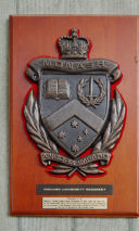 |
Waverley
(Monash) Civic Centre, Opening Plaque 1- 1984. |
A polished
aluminium plaque with recessed black lettering. |
The plaque is
placed on the wall in the Atrium/Foyer of the Civic
Centre, adjacent to and to the left (on entry) of the
concrete brick wall, at the southern door. |
71C1
|
WAVERLEY CIVIC CENTRE
OFFICIALLY
OPENED 22ND NOVEMBER, 1984
ACHIEVEMENT OF
THIS PROJECT IS ATTRIBUTABLE TO A TEAM EFFORT
OF
COUNCILLORS, ESPECIALLY MEMBERS OF THE CIVIC CENTRE
SUB-COMMITTEE, OFFICERS AND CONSULTANTS.
CIVIC CENTRE
SUB-COMMITTEE
THE COMMITTEE FIRST MET 26TH MAY, 1981 AND SERVED UNTIL
1ST AUGUST, 1985.
ITS CONTINUING
MEMBERS BEING CR. V.P. LeGRAND (CHAIRMAN) AND CRS. G.B.
FRECKER, R.D. HANNAN,
N.R.
HUTCHINSON-BROOKS AND L.M.RYAN.
COLIN J.
BOCK
A.G. THOMPSON
TOWN
CLERK
CITY
ENGINEER
J.N. WEBSTER
– DEPUTY TOWN CLERK
J.N. HALFORD – DEPUTY CITY ENGINEER
R.J. McNAMERA – SPECIAL PROJECTS MANAGER
PRINCIPAL CONSULTANTS
HARRY SEIDLER
& ASSOCIATES ARCHITECT CIVIL AND
CIVIC PTY. LTD. PROJECT MANAGER
THESE ACKNOWLEDGEMENTS ARE NOT AN EXHAUSTIVE LIST FOR IT
WAS THE CONTRIBUTIONS OF ALL COUNCILLORS AND ALL STAFF
OVER NEARLY A DECADE WHICH STEERED THE PROJECT FROM
CONCEPTION TO SUCCESSFUL COMPLETION.
|
Placed to
commemorate the official opening of the new Civic Centre
and Council Offices on 22 November, 1984.
Note, 19/12/2008:
Design/Completion 1982-1984, Waverley, Victoria
City of Waverley
3,500 sq m
Concrete structure,
split concrete blockwalls RAIA Award, 1985
The Local Government
complex stands on beautifully landscaped gently sloping
ground.
A two storey wing
contains the new council chamber, mayor’s office, council
facilities, function and meeting spaces. A three storey
wing, houses the new council offices. Between them is the
high central atrium foyer which can on occasions be used
for large gatherings, art shows and exhibitions.
A ramp leads up from
the lower entry to a freestanding elevator and an open
stair which gives access to all departmental offices. A
suspended bridge across the entry space connects the
council chamber and its ancillary public spaces with
executive offices.
The most distinctive
element in the new complex is the shape of the skylight
roof over the council chamber. It consists of two
opposing quadrant-shaped concrete walls forming a
semicircular vault which allows overhead daylight to
enter the otherwise windowless chamber.
Supported on a single
column standing in a circular reflecting pool, the
council chamber forms the main silhouette of the
building.
|
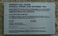 |
Waverley
(Monash) Civic Centre Opening Plaque 2 – 1984. |
A polished
aluminium plaque with recessed black lettering. |
The plaque is
placed on the wall in the Atrium/Foyer of the Civic
Centre, adjacent to and to the left (on entry) of the
concrete brick wall, at the eastern door. |
71C3
|
THE WAVERLEY CIVIC CENTRE WAS OFFICIALLY OPENED
BY HIS
EXCELLENCY THE GOVERNOR OF VICTORIA
REAR ADMIRAL
SIR BRIAN MURRAY, K.C.M.G., A.O.
ON THE TWENTY
SECOND DAY OF NOVEMBER 1984
COUNCILLORS
D.W. APPLETON
J.P.
G.B.
FRECKER
R.D. LYDON
R.D.
HANNAN
D.R. OLIN
T.M.
HERRERNAN
I.M. PEDERICK
N.H.
HUTCHINSON-BROOKE L.M.RYAN J.P.
V.P. LE
GRANDE
E.M. STURROCK
A.G.
THOMPSON L.G.E F.I.E. AUST.
COLIN J. BOCK F.I.M. J.P.
CITY
ENGINEER
TOWN CLERK
|
Placed to
commemorate the official opening of the new Civic Centre
and Council Offices on 22 November 1984.
Note, 19/12/2008:
Design/Completion 1982-1984
Waverley, Victoria
City of Waverley
3,500 sqm
Concrete structure,
split concrete blockwalls RAIA Award, 1985
The Local Government
complex stands on beautifully landscaped gently sloping
ground.
A two storey wing
contains the new council chamber, mayor’s office, council
facilities, function and meeting spaces. A three storey
wing, houses the new council offices. Between them is the
high central atrium foyer which can on occasions be used
for large gatherings, art shows and exhibitions.
A ramp leads up from
the lower entry to a freestanding elevator and an open
stair which gives access to all departmental offices. A
suspended bridge across the entry space connects the
council chamber and its ancillary public spaces with
executive offices.
The most distinctive
element in the new complex is the shape of the skylight
roof over the council chamber. It consists of two
opposing quadrant-shaped concrete walls forming a
semicircular vault which allows overhead daylight to
enter the otherwise windowless chamber.
Supported on a single
column standing in a circular reflecting pool, the
council chamber forms the main silhouette of the
building.
|
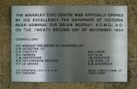 |
Uniting
Church, Glen Waverley Opening – 1962. |
A bronze
plaque with white lettering. |
Placed on the
brick wall at the southern end of the entrance foyer,
Glen Waverley Uniting Church, cnr. Bogong Avee and
Kingsway, Glen Waverley.
Not in its original place.
|
71C3
|
THESE BUILDINGS
WERE OPENED AND DEDICATED BY
THE REV. STANLEY I. WEEKS M.A.,
PRESIDENT OF THE CONFERENCE
ON THE OCCASION OF THE 98TH ANNIVERSARY
OF THE METHODIST CHURCH IN GLEN WAVERLEY
SUNDAY 12TH AUGUST, 1962.
MINISTER:- THE
REV. ANGUS C. ALLINSON
ARCHITECT
BUILDER
F.C.
ARMSTRONG
F.H. JENNINGS
A.R.I.B.A. A.R.A.I.A.
|
Note,
19/12/2008.
To
commemorate the opening of the original Methodist Church
in 1962. This plaque may be viewed by approaching the
church office on entry.
|
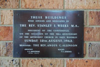 |
Uniting
Church, Glen Waverley, Extensions – 1982. |
A small
bronze plaque with black lettering. |
Placed on the
brick wall at the southern end of the entrance foyer,
Glen Waverley Uniting Church, cnr. Bogong Avenue and
Kingsway, Glen Waverley.
Not in its original place.
|
71C3
|
TO THE GLORY OF GOD
THIS EXTENSION
WAS COMPLETED
DECEMBER 1982
REV. IAN
PARTON MINISTER
|
Note,
19/12/2008.
To commemorate the extensions to the church buildings in
1982. This plaque may be viewed by approaching the church
office on entry. |
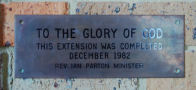 |
Uniting
Church, Glen Waverley Foundation Stone – 1964 |
A dark marble
foundation stone. Gold recessed lettering. |
Placed on the
brick wall at the southern end of the entrance foyer,
Glen Waverley Uniting Church, cnr. Bogong Avenue and
Kingsway, Glen Waverley. Not in
its original place. |
71C3
|
TO THE GLORY OF GOD
THIS STONE WAS
UNVEILED BY
MRS. G.
STEWART TAYLOR
ON THE 7TH
JUNE, 1964.
REV.
A.R.C. JAMIESON : MINISTER
|
Note,
19/12/2008.
It
was probably taken from the original Methodist church
building.
This plaque may be
viewed by approaching the church office on entry.
|
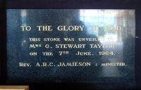 |
Uniting
Church, Glen Waverley Foundation Stone – 1956. |
A white
marble foundation stone. Gold recessed lettering. |
Placed into
the brick wall at the southern end of the entrance foyer,
Glen Waverley Uniting Church, cnr. Bogong Ave and
Kingsway, Glen Waverley. |
71C3
|
TO THE GLORY OF GOD
THIS STONE WAS
LAID BY
MRS. M.R.E. HOLLAND
28TH APRIL
1956
REVD. G. STEWART TAYLOR B.A., B.D.
MINISTER
KEITH
REID
E.C. BUTLER
ARCHITECT
BUILDER
|
Note,
19/12/2008.
The
stone was probably taken from the original Methodist
church building. This plaque may be viewed by approaching
the church office on entry.
|
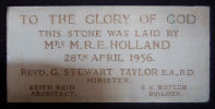 |
Uniting
Church, Glen Waverley Foundation Stone – 1962. |
A granite
foundation stone with recessed lettering which was
originally gold. |
Placed into
the brick wall at the southern end of the entrance foyer,
Glen Waverley Uniting Church, cnr. Bogong Ave and
Kingsway, Glen Waverley. |
71C3
|
TO THE GLORY OF GOD
THIS STONE WAS
LAID BY
THE REV.
STANLEY I. WEEKS, M.A.
PRESIDENT OF
THE CONFERENCE
20TH MAY 1962
|
Nte,
19/12/2008.
The
stone was probably taken from the original Methodit
church building. This stone may be viewed by approaching
the church office on entry.
|
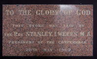 |
Uniting
Church, Glen Waverley, Opening – 1991. |
A bronze
plaque with raised bronze lettering. |
Placed on the
brick pillar to the right (west side) of the building’s
entrance from Bogong Ave. |
71C3
|
THIS CHURCH CENTRE
WAS OPENED AND DEDICATED
TO THE GLORY OF GOD
FOR THE MISSION OF THE CHURCH
ON 1ST DECEMBER 1991
BY THE MODERATOR
REV. JOHN BILLINGTON
AND THE PRESBYTERY
OF MAROONDAH
MINISTER REV.
IAN SMITH
|
Note,19/12/2008:
Placed to commemorate the opening of the current building
on the site, 1991. |
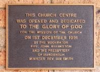 |
John B
Alabaster Memeorial Plaque, Glen Waverley – 1977. |
A brass
memorial plaque with recessed black lettering. |
On the
internal wall of the Monash City Church of Christ,
Montclair Ave, Glen Waverley – formerly Glen Waverley
Church of Christ. The plaque is located to the right of
the entrance adjacent to the Horizons bookshop and coffee
shop. |
71C3
|
IN MEMORY
OF
JOHN B. ALABASTER
LOVED ELDER OF THIS CHURCH
AGED 43
10-3-1934
26-5-1977
DEVOTED MEMBER
FOR 21 YEARS
|
Note,
19/12/2008.
Dedicated to John B. Alabaster. This plaque may be viewed
by approaching the church office on entry.
Historical note,
19/12/2008:
Monash City Church of
Christ, formerly known as Glen Waverley Church of Christ,
recently celebrated its 50th Anniversary with a large
celebration held at its Montclair Ave location.
The Church which was
founded by members of the Oakleigh Church of Christ,
began its life in the home of the Thoheys in Glen
Waverley, but soon out grew this location, and in 1954
began worshiping in a Tent, erected in Little street. The
Church moved to its current location in 1955, when the
first chapel was opened and dedicated.
ver the years, the
building has under gone many changes with the current
facilities being opened in 1990, which gave the community
an enlarged auditorium, more office space and also
allowed for the expansion of the New Horizons Bookshop
and Coffee Shop which opened in the early 1980’s.
|
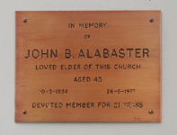 |
Legend Park
Tennis Club, Glen Waverley 10th Anniversary – 1984. |
A bronze
plaque with raised bronze lettering. |
Placed on the
eastern wall of the pavilion between two honour boards.
Capital Ave, Glen Waverley. |
62G12
|
LEGEND PARK TENNIS CLUB 18TH JUNE 1974
A PUBLIC MEETING INITIATED BY BERYL POLHILL
AND HELD ON THE ABOVE DATE LED TO
THE OFFICIAL CLUB FORMATION 28-11-1974.
COURTS OPENED 22-8-1976
BY CR.PERRY, J.P. MAYOR, CITY OF WAVERLEY
CLUB HOUSE OPENED 11-2-1979
BY CR. J.J. TAYLOR J.P.M MAYOR OF WAVERLEY
THIS PLAQUE WAS UNVEILED CR.G.B. FRECKER J.P.
AT THE TENTH ANNIIVERSARY CELEBRATIONS JUNE 1984
|
Note,
19/12/2008:
Erected and dedicated to commemorate the tenth
anniversary of the opening of the tennis club and
four-court complex in the clubrooms.
Access can only be when
members are in attendance at the club rooms.
|
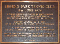 |
Salvation
Army Temple, Glen Waverley, Opening – 1987. |
Bronze plaque
with raised bronze lettering. |
Located on
the northern wall in the foyer of the complex at 958 High
Street Road, Glen Waverley – on the corner of High Street
Road and Kristen Close – enter from Kristen Close. |
71H1
|
THIS BUILDING
WAS DEDICATED
AND OPENED
TO THE GLORY OF GOD
BY
COMMISSIONER
DONALD CAMPBELL
27TH OF NOVEMBER, 1987
EVA
BURROWS
DONALD CAMPBELL
GENERAL
TERRITORIAL COMMANDER
|
Note,
19/12/2008:
Erected
to commemorate the opening of the Salvation Army Temple
and complex in 1987.
|
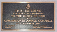 |
Salvation
Army Temple, Glen Waverley, Foundation Stone – 1913. |
A white
marble foundation stone with applied bronze lettering. |
Located on
the floor in the foyer of the complex at 958 High Street
Road, Glen Waverley, on the corner of High Street Road
and Kristen Close – enter from Kristen Close. |
71H1 |
THIS FOUNDATION STONE
WAS LAID BY
COMMISSIONER
DAVID C. LAMB
(INTERNATIONAL
SECRETARY, LONDON)
ON WEDNESDAY AUG. 20TH 1913.
BEING THE
FIRST ANNIVERSARY OF THE DEATH OF
GENERAL WILLIAM BOOTH
“EVERY HOUR AND EVERY POWER
FOR CHRIST AND DUTY”.
WM. BRAMWELL
BOOTH,
JAMES HAY,
GENERAL
COMMISSIONER
|
Note,
19/12/2008:
This foundation stone was not initially part of Mulgrave
Waverley Monash history, but is kept and permanently
displayed by Glen Waverley Salvation Army Corps at their
temple.
It was
originally the foundation stone for the Corps building in
Burwood Rd Hawthorn and was brought to Waverley on the
establishment of the temple in 1987.
|
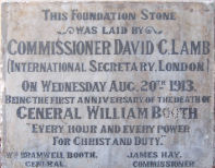 |
Winston Bell,
Legend Park Tennis Club, Glen Waverley – 1993. |
A brass
plaque with recessed, engraved black lettering mounted on
a timber base. |
Placed on the
eastern wall of the pavilion adjacent to the honour
boards. Capital Avenue, Glen Waverley. |
62G12
|
ERECTED BY THE MEMBERS OF
LEGEND PARK TENNIS CLUB
TO HONOUR THE
MEMORY OF
WINSTON BELL
FOR HIS
DEDICATED SERVICE TO
THE CLUB OVER MANY YEARS
OCTOBER 1993
|
Note,
19/12/2008:
Access
can only be when members are in attendance at the club
rooms.
|
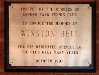 |
Jells Park –
Picnic Shelter, Wheelers Hill , Rotary – 1998. |
A silver
plaque with polished surface and black, recessed
lettering. |
On the east
facing wall of the Rotary picnic shelter, Jells Park,
Wheelers Hill. Located 200-300 metres to the south west
of the main building. South of the exit road and adjacent
to “Yabbie Hill” childrens’ playground. |
72A6
|
This picnic shelter is the project of the
ROTARY CLUB OF
GLEN WAVERLEY AND
PARKS VICTORIA
Original
concept and design by
PARKS VICTORIA
Constructed and financed by
ROTARY CLUB OF GLEN WAVERLEY
officially opened March 23rd 1998.
|
The club
members have funded and organised many projects, such as
the transport and restoration of a relocated old house to
the Glen Waverley Secondary Collage Camp at Nayook, built
and furnished CARA (a house for young girls), and the
construction of an Abbeyfield house, (a residence for
elderly people). The club has also built three shelters
at Jells Park and has hosted a number of exchange
students from around the world. The club has also
sponsored secondary college students to attend the
National Youth Science Forum and the Model United Nations
Assemblies and has supported many other community
activities. |
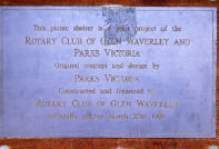 |
Jells Park –
Picnic Shelter, Wheelers Hill , Rotary. Geoff Alper –
2000. |
A copper
plaque with recessed black lettering mounted on a timber
base. |
On the
east-facing wall of the Rotary picnic shelter, Jells
Park, Wheelers Hill. Located 200-300 metres to the south
west of the main building. South of the exit road and
adjacent to “Yabbie Hill” childrens’
playground. |
72A6
|
IN MEMORY
OF
GEOFF ALPER
“Service above Self”
Rotary club of
Glen Waverley
Year 2000
|
Note,
7/1/2009:
Rotary Club of Glen Waverley:
Founded in 1972 through the sponsorship of the
Rotary Club of Waverley. The club began with 34
foundation members, with Bill Pratt as the Club
President. The Village Green Hotel was the venue for the
foundation meeting and has been the venue for all
meetings since, apart from a short period of time when
the hotel underwent extensive renovations. The club
members have funded and organised many projects, such as
the transport and restoration of a relocated old house to
the Glen Waverley Secondary Collage Camp at Nayook, built
and furnished CARA (a house for young girls), and the
construction of an Abbeyfield house, (a residence for
elderly people). The club has also built three shelters
at Jells Park and has hosted a number of exchange
students from around the world. The club has also
sponsored secondary college students to attend the
National Youth Science Forum and the Model United Nations
Assemblies and has supported many other community
activities.
|
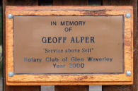 |
Jells Park –
Picnic Shelter, Wheelers Hill , Rotary – 2000. |
A polished
silver plaque with black slightly recessed lettering. |
On the east
facing wall of the Rotary picnic shelter, Jells Park,
Wheelers Hill. Located 200-300m to the west of the main
building. North of the exit road. |
72A6
|
This picnic shelter is a joint
project between the
Rotary Club of
Glen Waverley
and Parks Victoria.
Original
concept and design by Parks victoria
Constructed and financed by the
Rotary Cluub of Glen Waverley.
Officially opened 24 May 2000.
|
Note,
7/1/2009:
Rotary Club of Glen Waverley:
Founded in 1972 through the sponsorship of the
Rotary Club of Waverley. The club began with 34
foundation members, with Bill Pratt as the Club
President. The Village Green Hotel was the venue for the
foundation meeting and has been the venue for all
meetings since, apart from a short period of time when
the hotel underwent extensive renovations.
|
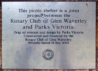 |
Amaroo
Neighbourhood Centre, Chadstone, Mural – 2005. |
A bronze
coated metal plaque with black recessed lettering. |
Located on
the corner of Amaroo and Bolwarra Streets, Chadstone.
Positioned on the south facing external brick wall of the
Amaroo Street Neighbourhood Centrem, to the left of the
Opportunity Shop rear entrance and loading bay. |
60 H2 |
This Mural and Sustainable Garden
has been proudly sponsored by
CVGT Employment and Training Specialists
through the Work for the Dole initiative with the support
of Amaroo
Neighbourhood House.
This site was
officially recognised
on
March 21st 2005
by
Senator Tsebin Tchen
Work for the
Dole
An Australian Government Initiative
“Work for the Dole is a Commonwealth Government
Initiative”
|
Note,
7/1/2009:
THE WORK FOR THE DOLE SCHEME,
In February 1997 the Howard Government announced
its intention to amend social security legislation to
introduce a scheme whereby unemployed young people would
be required to engage in part-time work in order to be
eligible for unemployment benefits. There will be a mix
of compulsory and voluntary work although it has been
stated that social security payments could be cut to
those who refuse to comply with the scheme. The
Government has decided that young people will be paid
award wages and therefore they will only work the hours
required to get unemployment allowance payment.
Participants will still be required to look for full time
work and unless employed full time will be registered as
unemployed.
Work-for-the-dole
projects:
Sustainable garden
project
The gardens of a
number of older Neighbourhood Renewal residents have been
redesigned by Ashburton Support Services. The service has
provided drought tolerant plants, mulch and design
layout.
AMAROO NEIGHBOURHOOD
CENTRE:
Amaroo Neighbourhood
Centre provides programs, activities, support groups,
child care, health related programs, learning and
recreational programs and one-off workshops, and aim to
keep all our activities as low cost as possible. We have
the services of a large op-shop that provides goods and
clothing at very reasonable prices, we also have an
annual art show and host the local Neighbourhood Watch
Group. All programs are integrated for persons with a
disability where appropriate. We are managed by a
committee of management and new members are always
welcome.
Waverley Adult
Literacy are also housed in Amaroo Neighbourhood House
and offer a variety of programs such as ESL classes,
computer classes etc
Historical Note,
7/1/2009:
Amaroo Neighbourhood
House was established on the site of a house,
“Wattle Grove” which was, for many years the
home of the farming Colwell Family. It was burnt down
c.1950. In 1966, the Malvern Corps of the Salvation Army
built a hall there. In 1981, Waverley Council purchased
the property from the Salvation Army and established a
Neighbourhood House, Op Shop and food bank in the
building.
Historical note,
7/1/2009:
SENATOR TSEBIN TCHEN.
Tsebin Tchen was our first Chinese-born federal
politician.
He was elected in
1998 from the difficult third spot on the Liberals’
Victorian Senate ticket, thanks mainly to Jeff Kennett,
his state’s flamboyant premier at the time, who used his
influence to get Tchen preselected ahead of a sitting
Liberal senator. When the preselection was held, Tchen
proved successful by a comfortable margin and in due
course, after a rather more strenuous effort in the
election itself, became the first Asian migrant to win a
seat in either house of the federal parliament.
But then in late
2004, Tchen was un-elected. That is, colleagues convinced
him the Liberal Party would withdraw its support if he
sought a second term in the general election of that
year.
So Tchen, rather than
embarrass his party as well as himself, withdrew his
nomination. Thus his six-year term ended on June 30, 2005
and so did his political career.
In spite of his
rather turbulent introduction, Tchen performed quietly in
parliament. He served on a large number of committees,
performed electoral duties energetically, and on the
floor of the senate was often seen but more rarely heard.
He was a strong advocate of multiculturalism but with a
forcefully positive approach: with the emphasis on
seeking common purposes rather than identifying
differences, and of demanding acceptance rather than just
tolerance. As chair of the government members’ policy
committee on immigration and multicultural affairs
between 2000 and 2004, an elected rather than a nominated
position, Tchen had an unpublicised, but nevertheless of
some influence, role to play as Australia tried to
grapple with the vexing issues of asylum seekers and boat
people.
|
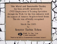 |
Amaroo
Neighbourhood Centre, Chadstone, Aerosol Art Project –
2008 |
A polished
silver metal plaque with recessed, white lettering. |
Located on
the corner of Amaroo and Bolwarra Streets, Chadstone.
Positioned on the east facing external brick wall of the
Amaroo Street Neighbourhood Centre – to the right of the
eastern car-park entrance to the building. |
60H2
|
CITY OF MONASH
Aerosol Art
Project
This mural has
been proudly sponsored by the City of Monash and
produced by the Activate youth Group
with the guidance of Christie Allison under the auspices
of Amaroo Neighbourhood Centre Inc.
This mural was officially unveiled by the mayor
Cr Paul Klisaris
on 25
February, 2008
Councillors
Mayor, Cr Paul
Klisaros
Cr Charlotte Baines Cr Joy Banerji Cr
Stephen Dimopolous
Cr Geoff Lake Cr Ryan Brown Cr Gerry
Kotlek Cr Dan Manzie
Cr Denise McGill Cr Tom Morrissey Cr Craig
Shiell
Victoria The Place To Be
Supported by the Victorian Government
|
Note,
7/1/2009:
The panel with the aerosol art is located to the left of
the car park entrance on the wall.
Cr Klisaris said the
Aerosol Art Project was funded through Council’s
Community Arts Grants and involved the creation of a
mural on the car park wall of the Neighbourhood Centre by
a group of young artists from ACTIVATE.
Artists Christie and
Peter Allison, who have extensive experience working with
young people in creating community art murals, were
responsible in overseeing the creation of the design and
supervision of the project.
The project is
collaboration between Monash Youth and Family Services,
the Amaroo Neighbourhood Centre and Council’s Community
Arts grants program.
Historical Note,
7/1/2009:
Amaroo Neighbourhood House was established on the site of
a house, “Wattle Grove” which was, for many
years the home of the farming Colwell Family. It was
burnt down c.1950. In 1966, the Malvern Corps of the
Salvation Army built a hall there. In 1981, Waverley
Council purchased the property from the Salvation Army
and established a Neighbourhood House, Op Shop and food
bank in the building.
|
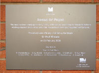 |
| 10 |
10 |
10 |
5 |
25 |
25 |
10 |