The Hume and Hovell Expedition pass Tatong
(So why didn't they spend the night at the pub?)

The Expedition
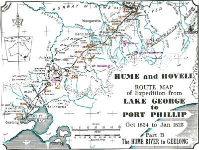
In 1824 Hamilton Hume and William Hilton Hovell, encouraged by Governor Brisbane, led an expedition of six convict servants overland to reach the Southern coast. (Map)
A fortnight after leaving Hume's home at Appin, the party left his station at Gunning, on October 17th 1824, with five bullocks, three horses and two carts. (They took the carts as far as the Goodradigbee River, near Wee Jasper. I wonder what became of them?)
They were the first whites know to see what we call the Murray River;  they christened it the Hume River for Hamilton Hume's father. However in 1830 Captain Charles Sturt, not realising he was the same river Hume and Hovell had encountered upstream, named the Murray River in honour of the then British Secretary of State for War and the Colonies, Sir George Murray. The name Murray stuck.
Arriving at the river, Hume & Hovell each carved their name into separate trees. Hamilton Hume's tree was burnt down in fires in the 1840. William Hovell's tree survives to date of writing, despite a termite attack, and in 2013 a clone of it was planted at Tatong.
Hume & Hovell arrived at Corio Bay on December 16th 1824.
Hovell miscalculated at the end, and they thought they were at Westernport.
 
Tatong
They crossed South Eastern part of the present shire of Benalla, and on the evening Saturday 27th November camped by Hollands Creek.
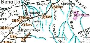
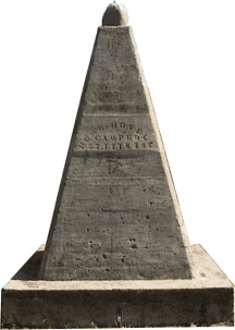
A monument by the Tolmie road, 7km South of Tatong, is near the place they are thought to have camped.
On Sunday 28th they climbed ‘Sunday Mount’, thought to be the hill immediately north of Samaria, overlooking Dodd’s Crossing at Fern Hills, South of Tatong.
They then crossed Samaria Creek and camped by the Broken River, which they called the ‘Swampy’, and the land about it ‘Norton's Meadows’

Below are some extracts from “Journey of Discovery to Port Phillip”.
 
Consequence
Their successful trip generated reports of hundreds of miles of good grazing land, well-watered and with a good climate. Many pastoralists began to move into this new territory. (That other people already occupied the land was not considered relevant. They weren't British.) John Batman formed the Port Phillip Association to investigate the area.

White settlers began to occupy the mainland west and north of Port Phillip; the Henty brothers settled at Portland in 1834. The authorities in Sydney were not keen, but in 1836 Governor Bourke approved the settlement by the Yarra, named it Melbourne and instructed the surveyor Robert Hoddle to lay out a township so that land sales could be held.

Pastoralists in New South Wales began in 1837 to move their stock across the Murray. They spread out along the tributaries of the Murray, stopping when they found an area they liked, until by 1840 almost all the open country north of the Great Dividing Range as far west as the Campaspe River was occupied.


Commemoration
About 1922 a committee was set up in Melbourne to help those living along the route taken by Hume and Hovell, to celebrate the centenary of the expedition.

This committee had representatives from the Education Department, National Parks Committee, Lands Department, R.A.C.V. and the Historical Society of Victoria, as well as the Tourist’s Resorts Committee and the Automobile Club of Victoria.
The chairman of the committee was ophthalmologist and university lecturer Sir James Barrett.

The Hume and Hovell Centenary Celebrations Committee appealed to municipal councils, school committees, inspectors of schools, and head teachers, to establish local committees to erect and unveil monuments (in the form of tablets, cairns, pyramids and obelisks) to mark the Hume and Hovell route.
As a result, 37 memorials were erected in Victoria.
The great majority of the memorials were erected in 1924, the year of the centenary.

Officials of the Hume and Hovell Centenary Celebrations Committee, and attendant parliamentarians, followed the approximate Hume and Hovell route from Albury to Lara by motor car, unveiling the local monuments as they went along.

The monument near Tatong has stamped upon it: "HUME & HOVELL CAMPED 27.11.1824"

("How many people get 37 memorials?" - Jill Lloyd, June 2005)

In November 2005 the Tatong Heritage Group Cleaned up the monument.

From “Journey of Discovery to Port Phillip”, which William Bland compiled from Hovell’s Journal. The text is available at http://gutenberg.net.au/explorers-journals.html

On Thursday, November 25 they crossed the ‘Ovens,’:
“- the water being so low, that it was found fordable in several places. The ford at which they passed was only three feet deep, and the bottom pebbly, so that although there was a considerable current, they were enabled to cross with the cattle laden. The banks of this river, are somewhat higher than those of the last two, and they appear less liable to floods.
The wild flax, (which is very similar to that of commerce,) grows here in profusion, generally about six feet high, also the native honeysuckle, and the grass-tree, both of which, (a circumstance by no means usual,) seem here to denote a good soil.”

“- Four miles and a half from the ‘Ovens’ they reach the summits of a range, whence they obtain a view of that river, coming from East by North, and evidently deriving its waters, from part of the ‘Alpine Chain.’ One of these snowcapped mountains, is now in sight, bearing South East, distant about twenty miles, there is also a singularly formed mountain, in the same direction, but much nearer, which from its shape, they name ‘Mount Buffalo.’

“- All the country in their line of route to-day, had been burned, and a little to the Westward of this line, the grass was still blazing to a considerable height.”

“ - Some of these hills are covered with a kind of scrub, and some consist of large masses of rock piled fantastically, as if by art, on each other. The crossing of these ranges was dreadfully distressing to the cattle. A little before sunset they pitched their tent near some water holes. The grass good. The natives evidently numerous.”


On Saturday, November 27.
"They start at six, weather at first threatening rain, but soon clearing up, and becoming oppressively sultry; proceed S W. about six miles, crossing in that short distance no less than five successive ranges near their western terminations, when the whole party, both men and cattle, being literally exhausted by fatigue and heat, they halt (at ten) near a run of water; but, on a spot where there was scarcely a blade of grass to be found. At four they resume their route and cross an extensive range, in effecting which the cattle are completely lamed. They halt, in consequence, at its foot; and where, happening to find a small supply of fodder for the cattle, they remain the night.

"While crossing one of these creeks, the bank fell in, by which accident one of the horses was thrown into the water, though, excepting its lading, which consisted of provisions, without sustaining any injury.

"This place appears, from the tracks that are observed, to be the resort of the kangaroo, but none are seen; and, even in the event of meeting any, the dogs are in so miserably famished a state, that they would be utterly unable to run them down. The creeks lately met with, all flow to the north west."

Sunday, November 28.
"The scanty supply of grass on the spot, where they remained the night, being all consumed, they start early this morning to forage for the cattle; proceed south west, and soon arrive on the summits of a range. Here they obtain an extensive view to the N W. consisting of a level country interspersed, as usual, with plains; of a small plain or meadow to the S W. and beyond this of mountainous ranges extending completely across their proposed line of route. Having descended this range, they cross a swamp which had been mistaken for a meadow, proceed four miles and then halt on a small patch of good grass. This, like all the other spaces of any extent, lying intermediately between the ranges, consists of a kind of meadow, divided along its centre by a small but rapid stream, is somewhat swampy, and in places near the water produces reeds. The ranges, as they recede to the N. West, subside gradually, until eventually they terminate in a level country.

"These meadows they named 'Norton's Meadows;' and a conical mount, situate at the extremity of the range to the northward, 'Norton's Mount,' after Mr. James Norton, of Sydney.
The hill which they had descended in the morning was designated 'Sunday Mount.' "
 

[Norton's Meadows are identified as the Broken River valley, and Norton's Mount as the peak about 3 kilometres north of Sunday Mount. To obtain the latitude by double altitudes Hovell must have used the latitude by account which he knew to be something less than 37º. Perhaps he meant to record 36º 38', even so an error of 15 kilometres. The true latitude is approximately 36º 47' S.]

"In the evening the men attempt to hunt, and meet with several kangaroos; but the dogs are utterly unable to run them down. The natives hereabouts are evidently numerous, as they conclude, from their fires, the smoke of which is observed in every direction. Yesterday their voices were distinctly heard, but none of them could be seen. Latitude, by double altitude, 38 deg. 38."


Exclusive to the Tatong Heritage Group!
Click here to learn what Hamilton Hume was singing as he rode home.


Contact us via tatongheritage at yahoo.com.au


Tatong Heritage Group Home

Hosted By VICNET