|
|

|
|||||||||
|

|
| Town, and Melbourne & Hobson's Bay Railway Piers, Sandridge. Willmore, A. (Arthur) 1814-1888, engraver. |
![]() NTRODUCTION
NTRODUCTION
Not far from the centre of Melbourne lies the remains of a small, wooden, Australian built vessel. The wreck was located by MAAV member Peter Taylor, on November 13, 1983. It is possible that the wreck has some connections with Victoria's military past, as a small silver button which was worn by members of the Victorian Volunteer Militia has been located on the site. The objective of this report is to introduce the reader to this interesting, unidentified wreck site.
SITE FEATURES
The site was a great deal more exposed when first seen in 1983, with the sand level being about 500mm lower than what it has been subsequently. A large piece of timber with a rabbet cut in, could be seen protruding from the sand at an angle. This is possibly the keel or thestempost. There is no sign of frames or the rebate in which the frames would butt into on this piece of timber. Scattered here and there over the site and towards shore, lay timbers, ranging in size from 50mm thick, through to about 200 mm and up to about 3 metres long. The depth of water is about 2.5 metres, whilst the distance to shore is about 50 metres. Lying detached from the keel, but attached to the sternpost, is a rudder. The bottom pintle on the rudder is a copper alloy, whilst the gudgeon is iron. The mixing of the two metals is not recommended, as this, in most cases, leads to bronze disease. The gudgeon is very unusual as it resembles a section of channel iron. This is bolted to the sternpost. This has not been previously noted on any other vessels. There is no evidence of copper bolts being used in the construction of the vessel and it appears as if it had been fastened with tree-nails. Lying near a large piece of unidentified timber, is a concreted mass of slag and stone. This does not appear to be a significant ballast mound, nor is there any in sight. The top of a frame pokes out of the sand. This has no ceiling or exterior planking attached. There is no evidence of any other frames protruding through the sand, no other frames have been seen, even when the sand level was much lower. We have been unable to find evidence of significant intact hull structure, such as planking attached to a row of frames, etc. Whether there is any buried under the sand, it is difficult to say.
Depending on the sand movement in the area, shards and pieces of what looks like iron pipe can be seen scattered around the site and all the way to the shore. The shards consist of pieces of black glass, blue and white pottery, tiles and slate. The reason for the shifting sand remains a mystery, as the area still has not been exposed as much as the first time the site was seen. The wreck seems well broken up. Whether this was done by blasting or by the elements, it is impossible to say at this stage. Since early 1986 the site has been mostly covered by sand. The rudder will occasionally emerge from the sand then disappear again.
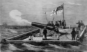 |
| Hobson's Bay defences - Colonial built Gun-Raft. |
AGE OF THE WRECK
To find out more about the age of the wreck, research was conducted at the map room of the Victorian State Library. An Admiralty chart surveyed by Commander Cox in 1864 proved to be a very fortunate and exciting find, as what proved to be the wreck site appeared marked on the chart. A transparency of the chart was purchased from the library. This proved to be very helpful with research later on. Next, a copy of an earlier chart surveyed in 1858 by G.H.W. Ross was obtained from the Ports and Harbours Hydrographic Department. This enabled us to establish the time frame in which the wrecking occurred. The years between 1858 and 1866 were then researched.
RELICS

|
Ship's bell
The image left displays front and side elevation, drawn by Peter Taylor.
The bell is made of copper alloy (weight 5 lb, 7 oz) and has no engraving on it to give an indication as to the name of the vessel. The bell would appear to be from the vessel.
Dark green bottle
Commonly called black glass, used for beer, porter, etc. This could have possibly washed in from the anchorage further out.

|
This grey coloured bottle has the name of the Sydney potter, T. Field, impressed in it. This type of bottle was known to have held ginger beer, mineral water, etc. This could have possibly washed in from the anchorage further out.
Wooden pulley block
This block is double sheaved. The wheels are side by side, being separated by the middle section of the block. The block has been rebated on the shell to take a rope strop. This could have possibly washed in from the anchorage further out.
The image left displays front, back and side elevation, drawn by Peter Taylor.
The button was worn on the uniform of a Victorian Volunteer Militia member, either Engineer or Infantry, circa 1860-1893. This button could have possibly washed in from somewhere else.
Copper alloy fitting
There are six retaining holes in this small fitting. On the raised top is a diamond shaped boss with a thread cut in. The fitting would seem to have been screwed to something like a hatch or a skylight. A bolt would have been turned to apply pressure to an arm which would stop it from slipping. The fitting would appear to be from the site.
With reference to the above, in particular the wooden pulley block, and note that in Elsum's History of Williamstown there is a mention of a gold digger landing at Williamstown in 1853. At the time, the beach was covered with a collection of drift spars, broken oars, ships blocks and dead-eyes.
MATCHING THE OLD CHART WITH THE MODERN CHART
To prove that the site on the 1864 Cox Chart was indeed the wreck we were researching, a method was invented for lining up the two charts. The transparency obtained from the library was cut down in size to fit a 35mm slide frame. A modern chart, which had previously had the site marked, was hung on the wall. A slide projector was then set up so to line up with the wall chart. When the projector became operational, the 1864 chart became superimposed on the modern chart. By adjusting the projector in and out, as well as the focusing, the two appeared in line. Next a pencil marked the wreck from the superimposed 1864 slide to the modem chart. The two points corresponded and so we knew then that we had the right site.
PROCEDURE
A team of divers was formed in early 1988 with the objectives of researching, measuring and the identification of the site. The team consisted of Maarten Vanetie, David Carol and Peter Taylor. The first two objectives were fulfilled, whilst the third is still a mystery.
The site was visited by David Carol and Peter Taylor on the 20 Feb 1988 to procure timber samples. Three different samples were taken, one from the keel/stem post, one from the frame and one from the rudder. All the samples proved to be different species and all were Australian except for the rudder. This suggests that the original might have been lost and a replacement one was shipped. The site that day was far from welcoming as there was a 20 knot south east wind blowing, sending in a half metre chop which lowered the underwater visibility to about 300mm. Our diving float proved a great target for the jet ski and sailboard riders.
The second visit on 15 May, 1988 by Maarten, David and Peter proved to be a much better day with good visibility and a calm sea. The exposed timber was triangulated in the space of an hour and a site plan produced. This day we exposed the unusual gudgeon. The triangulation procedure was carried out by hammering roofing nails into the exposed timber, then measurements were taken between these points. The measurements were then written down on an underwater slate. When this was drawn up later, we had a much better picture of how the site was set out. The width of the rabbet on the keel/stempost was measured to find the thickness of the planking, the width of the keel/stempost itself and the size of the frame as well. These measurements were later searched in the Australian Lloyds Rules and Regulations, Colonial Timbers used in Ship Building 1864 to determine the tonnage of the vessel (this can be found in the section relating to the timber samples).
TIMBER SAMPLES
Keel/Stempost
Stringy Bark - Eucalyptus obliqua: Found in Victoria and/or
Messmate - Eucalyptus fissilis: Found in Tasmania
Frame
Turpentine - Syncapia glomulifera: Found on the east coast of Australia between
Sydney and Cairns.
Rudder
Yellow pine - possibly Ponderosa pine, U.S.A.
CONCLUSION
In 1984 there was a great deal more wreckage protruding than today, 1996. The site remains safely buried at the moment, but the wreck will become exposed again when we have the right weather conditions.
ACKNOWLEDGMENTS
Many thanks to Denis Cahill for arranging the analysis of the slag sample. Also to the Ports & Harbours for the copy of the 1858 chart and to Terry Arnott for his objective reviewing of the first couple of drafts.
![]()
![]()
REFERENCES
Australian Lloyd's Rules and Regulations for Colonial Timbers Used in Ship Building, 1864 edition
The Oxford Companion to Ships and the Seas. Edited by Peter Kemp 1979.
Masting, Mast Making and the Rigging of Ships. Robert Kipling 1877.
The History of Williamstown. William Elsum 1985 reprint
Wood in Australia, Types, Properties and Uses. Keith R. Bootle.
Wrecks of Port Phillip. Peter Williams & Roderick Searle 1964
Australian Shipwrecks Vol 2. Jack Loney 1980
Shipping Arrivals and Departures. Marten Syme.
Deeds Not Words, The Victorian Navy. Wilson P. Evans.
 Need help with the terminology?
- Do you have any comments or questions regarding the Hobson's Bay Unidentified project report?
- If you have dived on the Hobson's Bay Unidentified have you any comments concerning the site?
- Do you have any information / photographs historical or otherwise which you believe may be useful to the MAAV for inclusion in the project report?
- Full credit will be given to any material if published.