|
|

|
|
|
![]() he three masted barque General Jessup was built in Philadelphia, United States in 1848. The vessel's official number was 41,475 and measured 99.4' x 23.4' x 8', was carvel built with a square stern and was 193.5 tons net. The General Jessup was registered in Baltimore in the United States. The registration was transferred to Melbourne in December 1854 and the registered owner of the vessel was J. Tulloch.
he three masted barque General Jessup was built in Philadelphia, United States in 1848. The vessel's official number was 41,475 and measured 99.4' x 23.4' x 8', was carvel built with a square stern and was 193.5 tons net. The General Jessup was registered in Baltimore in the United States. The registration was transferred to Melbourne in December 1854 and the registered owner of the vessel was J. Tulloch.
The General Jessup arrived in Port Albert for the first time early in 1862 inward bound from Newcastle. By early 1863 the General Jessup was listed as being a regular trader to Port Albert, mainly shipping livestock from that port to the Tasmanian mainland under the command of Captain Hodge. The General Jessup narrowly escaped being lost in February 1863. While departing Port Albert in the company of the Victoria and Kate Waters, the three vessels were struck by a strong gale. The buoys marking the channel were washed away leaving the three vessels vulnerable in a large sea. The General Jessup and the Kate Waters managed to clear the entrance and head out to sea. The Victoria was not so lucky she missed the channel striking the bank and became a total wreck.
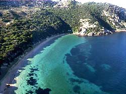
The General Jessup sailed from Hobart for Port Albert to load cattle on 25 June 1863. It is not known whether the General Jessup had a cargo for port Albert, it seems likely that they just had passengers aboard. A strong south - easterly gale forced the General Jessup to seek shelter at the Kent Group. On the evening of the 7 July the vessel dragged its anchors and went broadside on the beach at West Cove. The passengers and crew escaped without loss of life and were taken by the schooner Viblia to Melbourne arriving there on the 16 July.

|
The following extract from the Launceston Examiner 23 July 1863 gives an account of the wrecking:
In consequence of a heavy S.E. gale encountered on the 6th inst., came to anchor in West Cove (Kent Group) at 4.30 p.m., with forty five fathoms on the best bower; anchored there to wait daylight, not considering it prudent to run for the inlet, the weather being so very bad. On the 7th, wind still S.E., and blowing if anything harder that on the previous day, let go, at 11 a.m., another anchor, and payed out sixty fathoms on the port anchor. At 6.30 p.m., the ship drove and struck the ground; the keel remained striking for about half an hour, when she went broadside on to the beach, in the course of three hours filled, and on the 8th became a total wreck. Fortunately all hand succeeded in getting ashore safely, and on the Viblia arriving, on the 12th, went on board of her, and sailed from the group on the 13th, leaving behind Mrs. Black and Miss Balantine, two of the passengers. Mrs Hodges, Mr. And Mrs. Colbert and two children, and Mr. Connely, the other passengers, have arrived by the Viblia.
The days following the wreck saw much of her gear landed safely. A month later the master of the schooner Circassian reported that the General Jessup had been washed high up on the beach in West Cove.
The gale that claimed the General Jessup also caused the loss or stranding of the following vessels on the Victorian Coast; Peveril, Golden Spring, William Parsons, Almeda, William Hill, Emily and Colchester.
The wreck was reported in January 2001 to Mike Nash, Maritime Heritage Officer, Department of Primary Industry, Water and Environment, Tasmania. Mike contacted the Maritime Archaeology Association of Victoria who during an expedition in March 2001 to the Kent and Furneaux Groups located and surveyed the site.

|
Photo Jimmy Anderson |
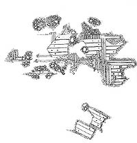
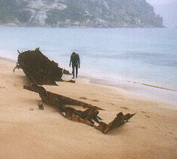
The Survey team consisted of MAAV members Malcolm Venturoni, John Osmond, John Munro, Lucy Lancellotti, Eric Langenberg, Jim Anderson, Harvey Sowerby and Priya Cardinalletti. The site was found in two metres of water approximately 25 meters off the beach and is located two thirds of the way between the hut at the northern end of West Cove and the wreck of the steel fishing boat St. Nicholas exposed on the beach.
The wreck site sits on sand and a sandstone reef. The site is close to the beach and would usually be covered in sand. The remains of the General Jessup consist of 54 foot long section of keel with frames and ceiling and outer planking attached. A large amount of ballast stones are present on the site. The outer planking is double fastened and much of the ceiling planking is still in place. The wreck remains indicates that the vessel was fastened using both copper alloy fastenings and trunnels (timber fastenings). Evidence of copper sheathing was located on the site. There were no artefacts recorded being exposed on the site.
Given the location of the wreck and that the timber sizes recorded match the size of a vessel of 200 tons, there is little doubt that this is the wreck of the General Jessup. However, timber samples were taken and the results when returned will confirm the identity of the wreck.
The wreck of the General Jessup is important, as it is a representative of the type of vessel operating through Bass Strait during the nineteenth century. The remains are protected under the Commonwealth Historic Shipwrecks Act 1981 and may yield buried beneath the sand information about life at sea during that period. The wreck warrants further work during future expeditions to the area.
REFERENCES
Launceston Examiner 23 July 1863
Loney J (1984)
Nash M (1997)
![]()
![]()
Broxam G & Nash M (1998)
Tasmanian Shipwrecks Volume 1, Navarine Publishing.
Ships & Shipwrecks at Port Albert, Marine History Publications.
A Maritime Archaeological Survey of the Kent Group,
Unpublished Report, Tasmanian Parks & Wildlife Service
|

