|
|
|
|||||||||
|
![]() uilt in 1879 as the Ribes, the Carmen was rigged as a brigantine and carried a variety of cargoes around the world. In 1909 it brought to Melbourne, 50-tuns of sea elephant oil from the Kerguelen Islands. A short time later it was purchased and renovated by the Carmen Shipping Co for use in the Tasmanian timber trade. In 1912, whilst on a voyage from Sydney to Hobart; and when off Montague Island the vessel became dismasted in a storm. It was taken in tow by the steamer Wee Clyde whereby they made their way back to Sydney. Later that year it was sold to ship owners; McIllwraith & McEacharn and towed to Melbourne to be converted into a coal hulk/lighter for the company. There it operated as a lighter for the next 24 years until meeting its end behind the old Williamstown Rifle Range.
uilt in 1879 as the Ribes, the Carmen was rigged as a brigantine and carried a variety of cargoes around the world. In 1909 it brought to Melbourne, 50-tuns of sea elephant oil from the Kerguelen Islands. A short time later it was purchased and renovated by the Carmen Shipping Co for use in the Tasmanian timber trade. In 1912, whilst on a voyage from Sydney to Hobart; and when off Montague Island the vessel became dismasted in a storm. It was taken in tow by the steamer Wee Clyde whereby they made their way back to Sydney. Later that year it was sold to ship owners; McIllwraith & McEacharn and towed to Melbourne to be converted into a coal hulk/lighter for the company. There it operated as a lighter for the next 24 years until meeting its end behind the old Williamstown Rifle Range.
|
A BRIEF HISTORY OF THE LIGHTERING TRADE
Commencing in the mid 1830's, lighters had been used extensively to move cargo around Port Phillip and the Port of Melbourne. As late as the 1960's a greatly diminished fleet continued to operate on Port Phillip. Lighters were normally un-rigged, un-powered vessels, these could be purposely built, or converted from old ships, cut down, and sometimes past their prime. They would be chartered to take cargo out to waiting ships, or to receive cargo for unloading at one of Melbourne's many wharves.
Known as "Old Stumpy"; the bar across the original entrance to the river Yarra prevented larger craft from travelling to Melbourne, and this, combined with the high cost of wharfage; set the scene for the development of the lightering trade.
The Victorian Lighterage Co., Henry Moss, Norman McLeod and other operators chartered their vessels on a daily or weekly basis. The bay ketch fleet; were small sail traders that would cart timber, shells, lime and any other cargo that would earn money for their owners around the bay. In slack times ketches would be made available for lightering charters. The numerous small river steamers and early steam tugs, that might be a ferry or excursion steamer one day and a tug the next, provided lighter towage services.
By 1847 some 10,000 pounds per year was being spent on the lighterage of cargo from Williamstown to Melbourne, most of which could have been saved if visiting vessels of 400 to 500 tons in size could have reached Queen's Wharf. During the 1850's gold rush, lighterage rates varied between 30/- to 50/; per ton.
Lighters were a microcosm of society, people who might have been well off or had stable positions on land, might through adversity, find themselves living aboard, or having jobs as watchmen on-board. Families lived and died on these vessels, a lighter keeper with a wife and five or six children was not uncommon. At times; education for the children living aboard was difficult; as the lighter might be in one port one day; and a day or two later in another; interrupting school lessons. Lightering, was not without its hazards as a number of wrecks occurred on Port Phillip.
Following the vast sums invested in rail infrastructure, wharves and later road transport, the remaining lighters managed to somehow eke out a living. They were usually loaded with baled wool at Geelong and towed to Port Melbourne or Williamstown where they were placed alongside overseas vessels and their cargo transferred for export. Eventually the one remaining lighterage firm, Victorian Lighterage Co folded; and the intra-bay trade ceased to operate, the lightering trade was finished, and one of the few remaining elements of this piece of Melbourne's maritime history is the Carmen.
LOCATING AND IDENTIFYING SITE
As a result of information supplied by local Williamstown maritime historian, Bob Leek, a search was made for two lighters known to have been burnt off the old Williamstown Rifle Range. On a subsequent search, the two sites were located on the edge of the reef. A surviving section of rudder and stern post was found, and this was used to identify the site as being the remains of the Carmen. This was achieved by measuring the dimensions of the stern post and matching the size against a Lloyds ship building guide for timber ship construction. The Ester, being a larger vessel would have had a stern post of greater dimensions.
THE END OF THE CARMEN
In what could only be described as a brazen act, the owners of the Carmen and Ester (having no further use for these vessels) decided as a means of disposal, and without any authority to do so, to run both lighters ashore at the back of Williamstown, and to set them on fire.
In February 1936, the Williamstown Advertiser describes the end of the Carmen, and the Ester:
Burning from stem to stern, two lighters, veterans of the days of sail, were burnt last Monday off the Williamstown rifle range. They are the Victorian Lighterage Co's Ester and Carmen. The manager of the company (Mr Treacy) set fire to the vessels on Monday afternoon. Formerly a three masted barque, the Ester was built in Scandinavia for shipping timber to Australia. Of 400tons, she was 35 years old and had been trading between Melbourne and Geelong for 20 years. The Carmen, a brigantine, was built in Italy 55 years ago. As a Norwegian whaling relief ship in the Antarctic she brought oil to Melbourne and Hobart. For 20 years she traded in the Bay.
In March 1936, at a Williamstown council meeting, there was a follow up to this incident:
From the Ports & Harbours branch, Melbourne, acknowledging receipt of objection to the granting of permits for the destruction of vessels off the beach at Williamstown, and intimating that permits are never issued to sink vessels in such circumstances. Also stating that suitable action is being taken through the Crown Law authorities with the object of compelling the owners to remove the lighters referred to.
|
SITE SURVEY
In March 1992; a base line was established for a trilateration survey. A tape measure was let out on the sand at the base of the reef where the wreck is located. Wooden pegs 300mm long were driven into the sand next to the tape with 50mm left showing. Roofing nails were hammered into the tops of these for hooking a tape measure onto.
The first trip to the site was taken in less than ideal conditions, with poor visibility and an uncomfortable surface chop, the day's work was finished with the establishment of the base line.
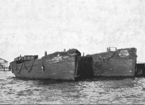
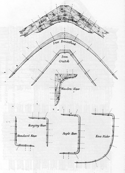
The return expedition was a complete opposite, with blue skies and 10 metres of underwater visibility. The clear water greatly aided the survey as numerous pieces of wreckage were observed and surveyed into the site plan. As a result of the wreck being on a bluestone reef and subject to southerly winds; not much timber structure has survived. The majority of wreck consists of iron knees, crutches and staples of various types scattered on and along the edge of the reef.
DIVING THE SITE
The wreck can be reached by swimming across the Jawbone at Williamstown and following the reef, passing the southern extremity of the peninsula before heading northwest. There on the edge of the reef, in about 4 metres of water are the remains of the Carmen. There is no reason to take a tank as the site can be easily visited with skin diving equipment.
CONCLUSION
The area in which the Carmen is located, was for many years an isolated part of the coast. However, with the land being developed for housing, it is possible that the site might be interfered with, destroying the archaeological value of this unique site. It is hoped that when divers do visit the site, they will look at and enjoy being able to dive a shipwreck so close to Melbourne.
SHIP DETAILS
Wood construction, built by N. Martinolich, Lussin Piccolo in 1879.
Official Number: 120767
266 tons register - 297 tons gross
Dimensions: 104.0 x 24.6 x 13.5 ft.
Owners:
Lloyd's Register of 1900/01 - Sainte Marthe, ex Anna, built as Ribes.
Lloyd's Register of 1909 - Carmen, ex Maurice, ex Sainte Marthe, ex Anna, built as Ribes.
ANZ Register of Shipping 1921/22 - Carmen, Registered: Melbourne 1911, Owners: Victorian Lighterage Pty Ltd.