| Keilor
Historical Society Inc.1990 |
|
|
|
 |
|
Highlights
which exemplify the features of Keilor Region.
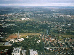
Keilor 2005
Photo
left: Avondale Heights, Maidston, Braybrook by Andreas
Makarewitsch, June 2005. |
|
Aerial
photographs of Keilor, 2005
by Andreas Makarewitsch
Maribyrnong River photographs, 2005-06
by Andreas Makarewitsch
"The City of Brimbank was formed on 15 December 1994,
following the amalgamation of the former Cities of Keilor
and Sunshine. It was a union of two municipalities with
diverse characteristics in a period of significant change
for Local Government in Victoria.
With an area of 123 square kilometres, Brimbank is the second
largest municipality in Melbourne and the largest in the
Western Region. It is approximately 20 kilometres from the
CBD.
Brimbank is a dynamic and rapidly growing city which encompasses
25 new and established suburbs including Albion, Cairnlea,
Deer Park, Delahey, Hillside, Keilor, Kings Park, St Albans,
Sunshine, Sydenham and Taylors Lakes.
In
2005, following more than a decade of rapid growth the population
has grown to more than 175,000 and is estimated to increase
to 200,766 by the year 2015."
(Source: www.brimbank.vic.gov.au)
How Keilor has grown.
In 1962 the population was 33,249 and the number of dwellings
was 7,898.
Rates
"The rate struck on Dec. 8, 1962, is 3,746 d. in the
1 (pound) on the Unimproved Capital Value. Equivalent Net
Annual Value of 2/11.265 in the 1 (pound) compared with
7.5 d. in the 1 (pound) in 1961/62."
(Source: City of Keilor Centenary flyer)
|
|
|
|
|